You are here: Home > Network List > IU - Global Seismograph Network (GSN - IRIS/USGS) Stations List
> Station BILL Bilibino, Russia > Earthquake Result Viewer
BILL Bilibino, Russia - Earthquake Result Viewer
| Earthquake location: |
South Of Fiji Islands |
| Earthquake latitude/longitude: |
-23.0/-177.2 |
| Earthquake time(UTC): |
2013/05/23 (143) 17:19:04 GMT |
| Earthquake Depth: |
174 km |
| Earthquake Magnitude: |
7.4 MW, 6.6 MB, 7.4 MW |
| Earthquake Catalog/Contributor: |
NEIC PDE/NEIC PDE-W |
|
| Network: |
IU Global Seismograph Network (GSN - IRIS/USGS) |
| Station: |
BILL Bilibino, Russia |
| Lat/Lon: |
68.07 N/166.45 E |
| Elevation: |
320 m |
|
| Distance: |
91.6 deg |
| Az: |
353.939 deg |
| Baz: |
164.993 deg |
| Ray Param: |
0.041506115 |
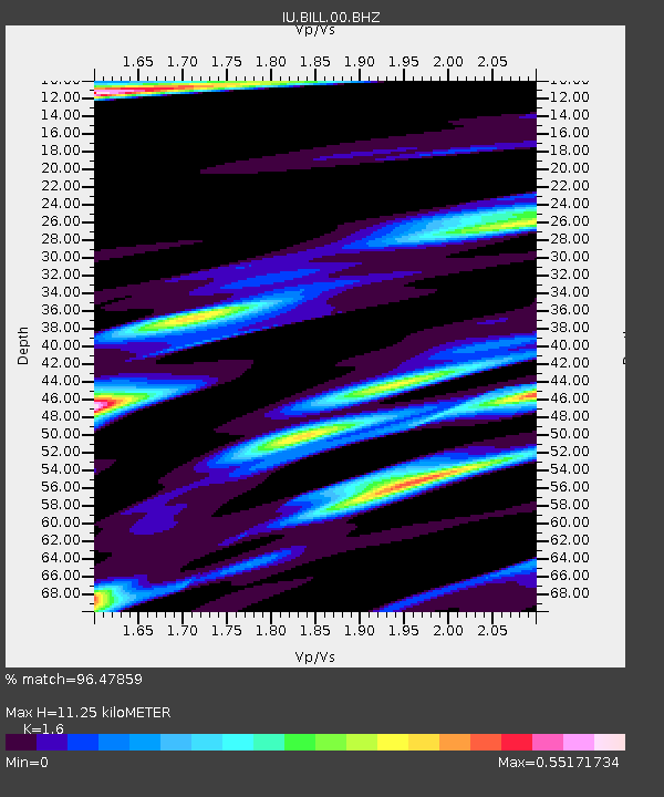
| Estimated Moho Depth: |
11.25 km |
| Estimated Crust Vp/Vs: |
1.60 |
| Assumed Crust Vp: |
6.577 km/s |
| Estimated Crust Vs: |
4.11 km/s |
| Estimated Crust Poisson's Ratio: |
0.18 |
|
| Radial Match: |
96.47859 % |
| Radial Bump: |
400 |
| Transverse Match: |
89.674805 % |
| Transverse Bump: |
400 |
| SOD ConfigId: |
512894 |
| Insert Time: |
2013-09-14 15:59:04.113 +0000 |
| GWidth: |
2.5 |
| Max Bumps: |
400 |
| Tol: |
0.001 |
|
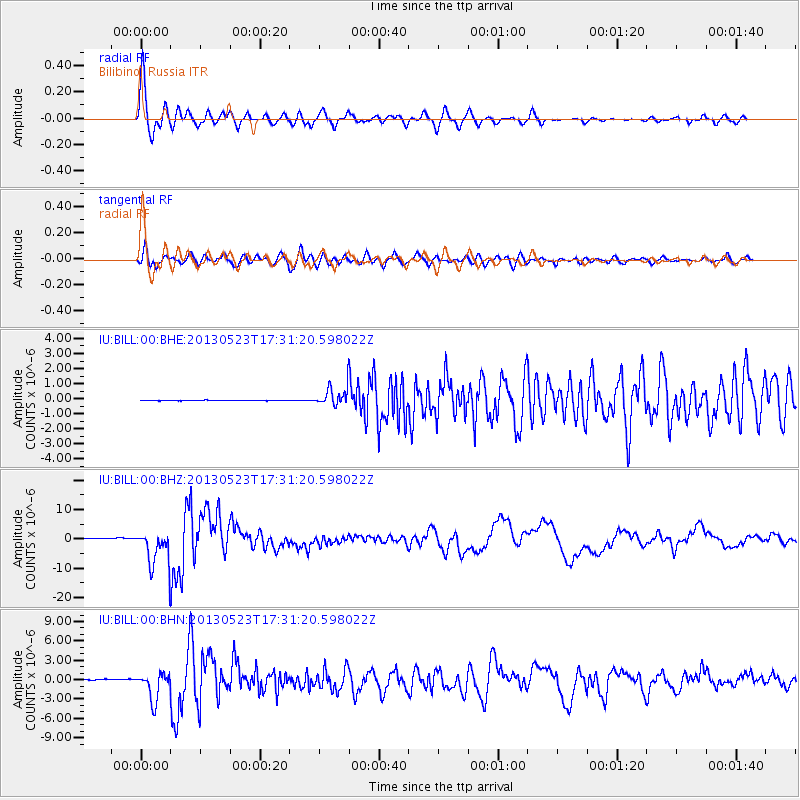
Signal To Noise
| Channel | StoN | STA | LTA |
| IU:BILL:00:BHZ:20130523T17:31:20.598022Z | 28.5395 | 6.0680727E-6 | 2.1262015E-7 |
| IU:BILL:00:BHN:20130523T17:31:20.598022Z | 29.876219 | 2.1656863E-6 | 7.248863E-8 |
| IU:BILL:00:BHE:20130523T17:31:20.598022Z | 36.595257 | 6.138733E-7 | 1.6774669E-8 |
| Arrivals |
| Ps | 1.1 SECOND |
| PpPs | 4.3 SECOND |
| PsPs/PpSs | 5.4 SECOND |


