You are here: Home > Network List > IU - Global Seismograph Network (GSN - IRIS/USGS) Stations List
> Station GUMO Guam, Mariana Islands > Earthquake Result Viewer
GUMO Guam, Mariana Islands - Earthquake Result Viewer
| Earthquake location: |
South Of Fiji Islands |
| Earthquake latitude/longitude: |
-23.0/-177.2 |
| Earthquake time(UTC): |
2013/05/23 (143) 17:19:04 GMT |
| Earthquake Depth: |
174 km |
| Earthquake Magnitude: |
7.4 MW, 6.6 MB, 7.4 MW |
| Earthquake Catalog/Contributor: |
NEIC PDE/NEIC PDE-W |
|
| Network: |
IU Global Seismograph Network (GSN - IRIS/USGS) |
| Station: |
GUMO Guam, Mariana Islands |
| Lat/Lon: |
13.59 N/144.87 E |
| Elevation: |
170 m |
|
| Distance: |
52.0 deg |
| Az: |
310.676 deg |
| Baz: |
134.057 deg |
| Ray Param: |
0.066468336 |
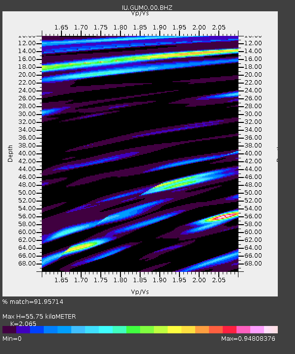
| Estimated Moho Depth: |
55.75 km |
| Estimated Crust Vp/Vs: |
2.07 |
| Assumed Crust Vp: |
4.802 km/s |
| Estimated Crust Vs: |
2.325 km/s |
| Estimated Crust Poisson's Ratio: |
0.35 |
|
| Radial Match: |
91.95714 % |
| Radial Bump: |
400 |
| Transverse Match: |
83.62386 % |
| Transverse Bump: |
400 |
| SOD ConfigId: |
512894 |
| Insert Time: |
2013-09-14 15:59:24.675 +0000 |
| GWidth: |
2.5 |
| Max Bumps: |
400 |
| Tol: |
0.001 |
|

Signal To Noise
| Channel | StoN | STA | LTA |
| IU:GUMO:00:BHZ:20130523T17:27:25.319Z | 42.570282 | 2.839586E-5 | 6.670348E-7 |
| IU:GUMO:00:BH1:20130523T17:27:25.319Z | 15.978285 | 9.746454E-6 | 6.099812E-7 |
| IU:GUMO:00:BH2:20130523T17:27:25.319Z | 14.358538 | 9.223506E-6 | 6.423708E-7 |
| Arrivals |
| Ps | 13 SECOND |
| PpPs | 35 SECOND |
| PsPs/PpSs | 47 SECOND |


