You are here: Home > Network List > IU - Global Seismograph Network (GSN - IRIS/USGS) Stations List
> Station NWAO Narrogin, Australia > Earthquake Result Viewer
NWAO Narrogin, Australia - Earthquake Result Viewer
| Earthquake location: |
South Of Fiji Islands |
| Earthquake latitude/longitude: |
-23.0/-177.2 |
| Earthquake time(UTC): |
2013/05/23 (143) 17:19:04 GMT |
| Earthquake Depth: |
174 km |
| Earthquake Magnitude: |
7.4 MW, 6.6 MB, 7.4 MW |
| Earthquake Catalog/Contributor: |
NEIC PDE/NEIC PDE-W |
|
| Network: |
IU Global Seismograph Network (GSN - IRIS/USGS) |
| Station: |
NWAO Narrogin, Australia |
| Lat/Lon: |
32.93 S/117.24 E |
| Elevation: |
380 m |
|
| Distance: |
57.9 deg |
| Az: |
244.624 deg |
| Baz: |
98.169 deg |
| Ray Param: |
0.06263044 |
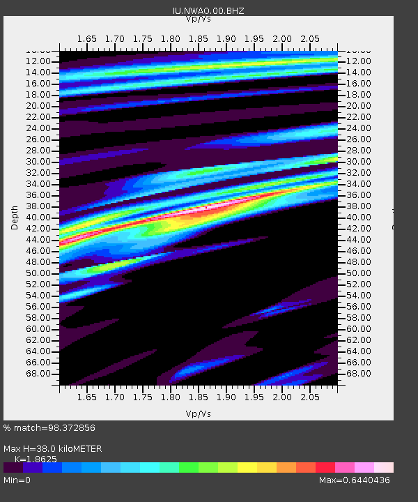
| Estimated Moho Depth: |
38.0 km |
| Estimated Crust Vp/Vs: |
1.86 |
| Assumed Crust Vp: |
6.419 km/s |
| Estimated Crust Vs: |
3.447 km/s |
| Estimated Crust Poisson's Ratio: |
0.30 |
|
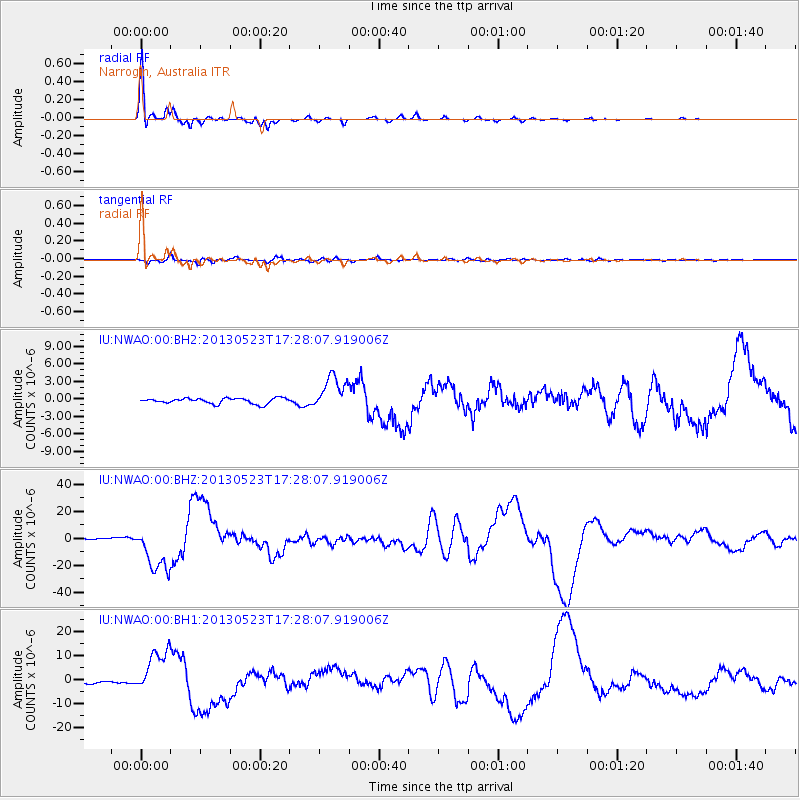
| Radial Match: |
98.372856 % |
| Radial Bump: |
297 |
| Transverse Match: |
86.545235 % |
| Transverse Bump: |
400 |
| SOD ConfigId: |
512894 |
| Insert Time: |
2013-09-14 15:59:45.797 +0000 |
| GWidth: |
2.5 |
| Max Bumps: |
400 |
| Tol: |
0.001 |
|
Signal To Noise
| Channel | StoN | STA | LTA |
| IU:NWAO:00:BHZ:20130523T17:28:07.919006Z | 30.937346 | 1.7481765E-5 | 5.6506997E-7 |
| IU:NWAO:00:BH1:20130523T17:28:07.919006Z | 17.529533 | 9.396741E-6 | 5.3605197E-7 |
| IU:NWAO:00:BH2:20130523T17:28:07.919006Z | 6.1751757 | 2.8983784E-6 | 4.6935966E-7 |
| Arrivals |
| Ps | 5.3 SECOND |
| PpPs | 16 SECOND |
| PsPs/PpSs | 22 SECOND |


