You are here: Home > Network List > PS - Pacific21 Stations List
> Station TSK Tsukuba, Japan > Earthquake Result Viewer
TSK Tsukuba, Japan - Earthquake Result Viewer
| Earthquake location: |
Southeast Of Loyalty Islands |
| Earthquake latitude/longitude: |
-23.0/169.9 |
| Earthquake time(UTC): |
1995/05/16 (136) 20:12:45 GMT |
| Earthquake Depth: |
33 km |
| Earthquake Magnitude: |
6.8 MB, 7.7 MS, 7.7 UNKNOWN, 7.7 MW |
| Earthquake Catalog/Contributor: |
WHDF/NEIC |
|
| Network: |
PS Pacific21 |
| Station: |
TSK Tsukuba, Japan |
| Lat/Lon: |
36.21 N/140.11 E |
| Elevation: |
350 m |
|
| Distance: |
65.3 deg |
| Az: |
333.755 deg |
| Baz: |
149.749 deg |
| Ray Param: |
0.058317386 |
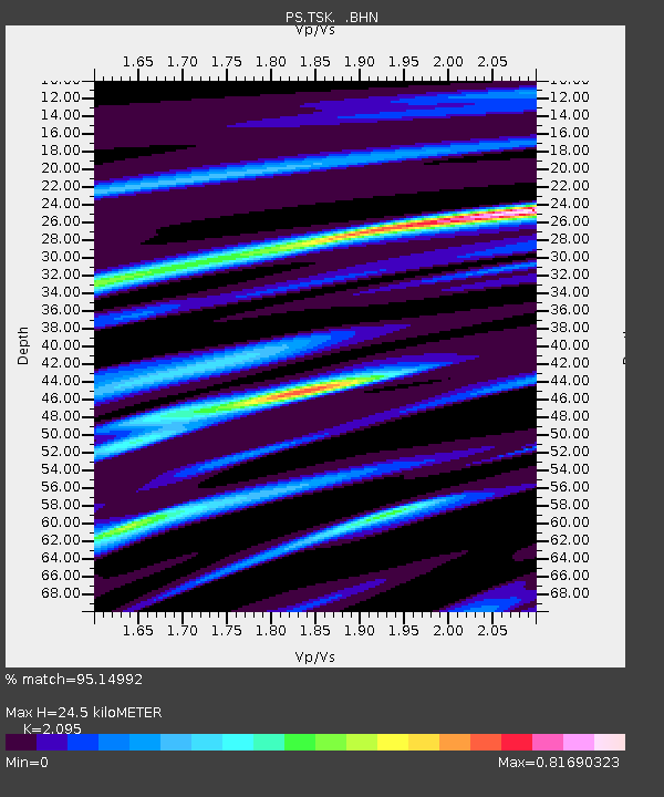
| Estimated Moho Depth: |
24.5 km |
| Estimated Crust Vp/Vs: |
2.10 |
| Assumed Crust Vp: |
6.24 km/s |
| Estimated Crust Vs: |
2.979 km/s |
| Estimated Crust Poisson's Ratio: |
0.35 |
|
| Radial Match: |
95.14992 % |
| Radial Bump: |
356 |
| Transverse Match: |
89.049805 % |
| Transverse Bump: |
400 |
| SOD ConfigId: |
6273 |
| Insert Time: |
2010-02-27 03:52:41.900 +0000 |
| GWidth: |
2.5 |
| Max Bumps: |
400 |
| Tol: |
0.001 |
|

Signal To Noise
| Channel | StoN | STA | LTA |
| PS:TSK: :BHN:19950516T20:22:53.350Z | 1.3191769 | 1.4514293E-6 | 1.1002536E-6 |
| PS:TSK: :BHE:19950516T20:22:53.350Z | 1.9362038 | 1.5499485E-6 | 8.0050893E-7 |
| PS:TSK: :BHZ:19950516T20:22:53.350Z | 3.3818853 | 3.8094008E-6 | 1.1264134E-6 |
| Arrivals |
| Ps | 4.4 SECOND |
| PpPs | 12 SECOND |
| PsPs/PpSs | 16 SECOND |


