You are here: Home > Network List > PS - Pacific21 Stations List
> Station TSK Tsukuba, Japan > Earthquake Result Viewer
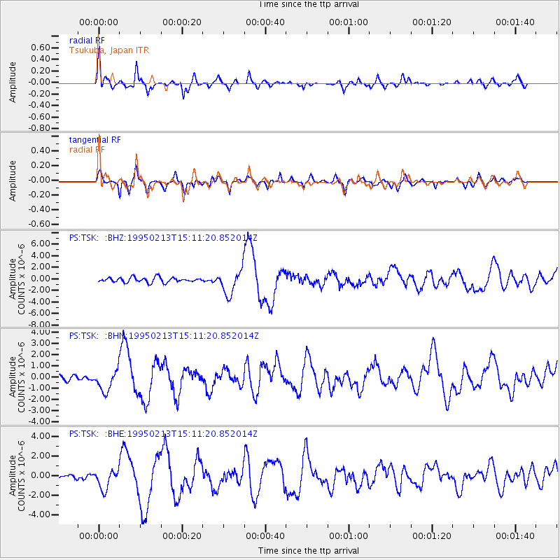
TSK Tsukuba, Japan - Earthquake Result Viewer

| Earthquake location: |
Halmahera, Indonesia |
| Earthquake latitude/longitude: |
-1.4/127.5 |
| Earthquake time(UTC): |
1995/02/13 (044) 15:04:26 GMT |
| Earthquake Depth: |
33 km |
| Earthquake Magnitude: |
6.2 MB, 6.8 MS, 6.8 UNKNOWN, 6.7 MW |
| Earthquake Catalog/Contributor: |
WHDF/NEIC |
|
| Network: |
PS Pacific21 |
| Station: |
TSK Tsukuba, Japan |
| Lat/Lon: |
36.21 N/140.11 E |
| Elevation: |
350 m |
|
| Distance: |
39.2 deg |
| Az: |
16.204 deg |
| Baz: |
200.179 deg |
| Ray Param: |
0.07507718 |
| Estimated Moho Depth: |
69.75 km |
| Estimated Crust Vp/Vs: |
1.77 |
| Assumed Crust Vp: |
6.24 km/s |
| Estimated Crust Vs: |
3.52 km/s |
| Estimated Crust Poisson's Ratio: |
0.27 |
|
| Radial Match: |
81.6882 % |
| Radial Bump: |
400 |
| Transverse Match: |
77.30292 % |
| Transverse Bump: |
400 |
| SOD ConfigId: |
6273 |
| Insert Time: |
2010-02-27 03:52:49.724 +0000 |
| GWidth: |
2.5 |
| Max Bumps: |
400 |
| Tol: |
0.001 |
|
Signal To Noise
| Channel | StoN | STA | LTA |
| PS:TSK: :BHN:19950213T15:11:20.852014Z | 3.9948833 | 1.000381E-6 | 2.5041558E-7 |
| PS:TSK: :BHE:19950213T15:11:20.852014Z | 3.371024 | 1.0128631E-6 | 3.0046155E-7 |
| PS:TSK: :BHZ:19950213T15:11:20.852014Z | 5.358193 | 2.2290533E-6 | 4.1600842E-7 |
| Arrivals |
| Ps | 9.2 SECOND |
| PpPs | 29 SECOND |
| PsPs/PpSs | 38 SECOND |


