You are here: Home > Network List > JP - Japan Meteorological Agency Seismic Network Stations List
> Station JHJ2 Hachijojima Island > Earthquake Result Viewer
JHJ2 Hachijojima Island - Earthquake Result Viewer
| Earthquake location: |
South Of Fiji Islands |
| Earthquake latitude/longitude: |
-23.0/-177.2 |
| Earthquake time(UTC): |
2013/05/23 (143) 17:19:04 GMT |
| Earthquake Depth: |
174 km |
| Earthquake Magnitude: |
7.4 MW, 6.6 MB, 7.4 MW |
| Earthquake Catalog/Contributor: |
NEIC PDE/NEIC PDE-W |
|
| Network: |
JP Japan Meteorological Agency Seismic Network |
| Station: |
JHJ2 Hachijojima Island |
| Lat/Lon: |
33.12 N/139.81 E |
| Elevation: |
70 m |
|
| Distance: |
69.2 deg |
| Az: |
322.293 deg |
| Baz: |
137.818 deg |
| Ray Param: |
0.055300444 |
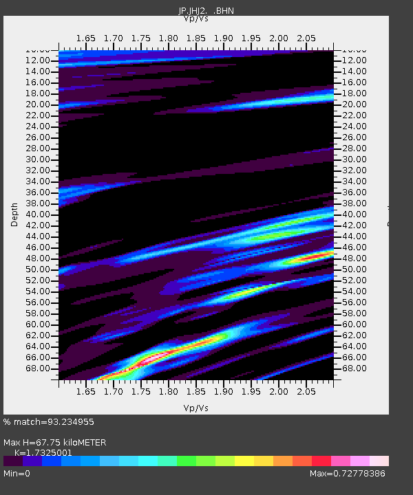
| Estimated Moho Depth: |
67.75 km |
| Estimated Crust Vp/Vs: |
1.73 |
| Assumed Crust Vp: |
4.662 km/s |
| Estimated Crust Vs: |
2.691 km/s |
| Estimated Crust Poisson's Ratio: |
0.25 |
|
| Radial Match: |
93.234955 % |
| Radial Bump: |
400 |
| Transverse Match: |
91.385994 % |
| Transverse Bump: |
400 |
| SOD ConfigId: |
512894 |
| Insert Time: |
2013-09-14 16:01:13.612 +0000 |
| GWidth: |
2.5 |
| Max Bumps: |
400 |
| Tol: |
0.001 |
|

Signal To Noise
| Channel | StoN | STA | LTA |
| JP:JHJ2: :BHZ:20130523T17:29:21.849976Z | 7.317734 | 1.7383258E-5 | 2.3754974E-6 |
| JP:JHJ2: :BHN:20130523T17:29:21.849976Z | 4.0059814 | 6.8296727E-6 | 1.7048689E-6 |
| JP:JHJ2: :BHE:20130523T17:29:21.849976Z | 3.2129529 | 6.869027E-6 | 2.1379171E-6 |
| Arrivals |
| Ps | 11 SECOND |
| PpPs | 39 SECOND |
| PsPs/PpSs | 50 SECOND |


