You are here: Home > Network List > PS - Pacific21 Stations List
> Station TSK Tsukuba, Japan > Earthquake Result Viewer
TSK Tsukuba, Japan - Earthquake Result Viewer
| Earthquake location: |
Myanmar-India Border Region |
| Earthquake latitude/longitude: |
25.0/95.3 |
| Earthquake time(UTC): |
1995/05/06 (126) 01:59:07 GMT |
| Earthquake Depth: |
122 km |
| Earthquake Magnitude: |
6.4 MB, 6.5 UNKNOWN, 6.4 MW |
| Earthquake Catalog/Contributor: |
WHDF/NEIC |
|
| Network: |
PS Pacific21 |
| Station: |
TSK Tsukuba, Japan |
| Lat/Lon: |
36.21 N/140.11 E |
| Elevation: |
350 m |
|
| Distance: |
39.8 deg |
| Az: |
62.833 deg |
| Baz: |
266.521 deg |
| Ray Param: |
0.07434773 |
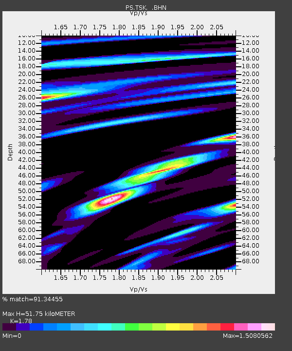
| Estimated Moho Depth: |
51.75 km |
| Estimated Crust Vp/Vs: |
1.78 |
| Assumed Crust Vp: |
6.24 km/s |
| Estimated Crust Vs: |
3.506 km/s |
| Estimated Crust Poisson's Ratio: |
0.27 |
|
| Radial Match: |
91.34455 % |
| Radial Bump: |
400 |
| Transverse Match: |
83.6306 % |
| Transverse Bump: |
400 |
| SOD ConfigId: |
6273 |
| Insert Time: |
2010-02-27 03:52:55.207 +0000 |
| GWidth: |
2.5 |
| Max Bumps: |
400 |
| Tol: |
0.001 |
|
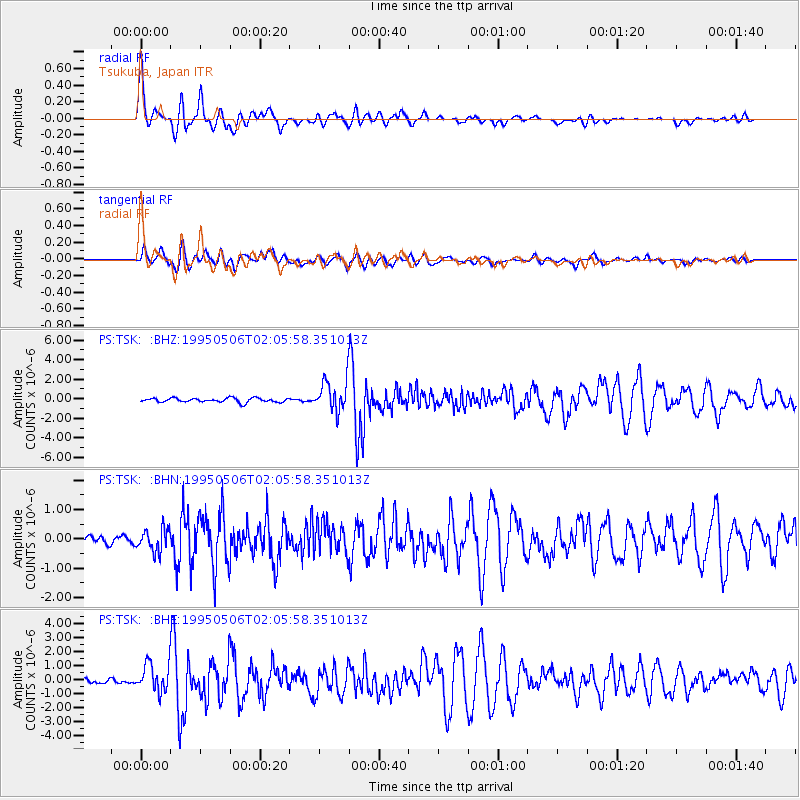
Signal To Noise
| Channel | StoN | STA | LTA |
| PS:TSK: :BHN:19950506T02:05:58.351013Z | 1.9930857 | 3.7914384E-7 | 1.9022956E-7 |
| PS:TSK: :BHE:19950506T02:05:58.351013Z | 6.124015 | 1.0272993E-6 | 1.6774932E-7 |
| PS:TSK: :BHZ:19950506T02:05:58.351013Z | 7.3832135 | 1.6027252E-6 | 2.170769E-7 |
| Arrivals |
| Ps | 6.9 SECOND |
| PpPs | 22 SECOND |
| PsPs/PpSs | 29 SECOND |


