You are here: Home > Network List > PS - Pacific21 Stations List
> Station TSK Tsukuba, Japan > Earthquake Result Viewer
TSK Tsukuba, Japan - Earthquake Result Viewer

| Earthquake location: |
Timor Region |
| Earthquake latitude/longitude: |
-8.4/125.1 |
| Earthquake time(UTC): |
1995/05/14 (134) 11:33:21 GMT |
| Earthquake Depth: |
33 km |
| Earthquake Magnitude: |
6.1 MB, 6.9 MS, 7.1 UNKNOWN, 6.9 MW |
| Earthquake Catalog/Contributor: |
WHDF/NEIC |
|
| Network: |
PS Pacific21 |
| Station: |
TSK Tsukuba, Japan |
| Lat/Lon: |
36.21 N/140.11 E |
| Elevation: |
350 m |
|
| Distance: |
46.6 deg |
| Az: |
16.783 deg |
| Baz: |
200.686 deg |
| Ray Param: |
0.07050117 |
| Estimated Moho Depth: |
69.75 km |
| Estimated Crust Vp/Vs: |
1.77 |
| Assumed Crust Vp: |
6.24 km/s |
| Estimated Crust Vs: |
3.515 km/s |
| Estimated Crust Poisson's Ratio: |
0.27 |
|
| Radial Match: |
84.597694 % |
| Radial Bump: |
400 |
| Transverse Match: |
77.89443 % |
| Transverse Bump: |
400 |
| SOD ConfigId: |
6273 |
| Insert Time: |
2010-02-27 03:52:58.570 +0000 |
| GWidth: |
2.5 |
| Max Bumps: |
400 |
| Tol: |
0.001 |
|
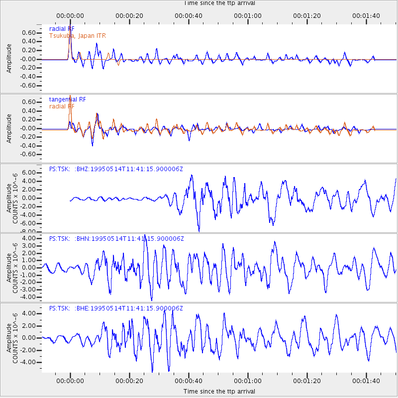
Signal To Noise
| Channel | StoN | STA | LTA |
| PS:TSK: :BHN:19950514T11:41:15.900006Z | 1.0642834 | 3.4948164E-7 | 3.2837272E-7 |
| PS:TSK: :BHE:19950514T11:41:15.900006Z | 2.1047354 | 6.639106E-7 | 3.154366E-7 |
| PS:TSK: :BHZ:19950514T11:41:15.900006Z | 2.9273043 | 7.566119E-7 | 2.584671E-7 |
| Arrivals |
| Ps | 9.2 SECOND |
| PpPs | 29 SECOND |
| PsPs/PpSs | 38 SECOND |


