You are here: Home > Network List > PS - Pacific21 Stations List
> Station TSK Tsukuba, Japan > Earthquake Result Viewer
TSK Tsukuba, Japan - Earthquake Result Viewer

| Earthquake location: |
New Ireland Region, P.N.G. |
| Earthquake latitude/longitude: |
-4.0/153.9 |
| Earthquake time(UTC): |
1995/06/24 (175) 06:58:06 GMT |
| Earthquake Depth: |
386 km |
| Earthquake Magnitude: |
6.2 MB, 6.8 UNKNOWN |
| Earthquake Catalog/Contributor: |
WHDF/NEIC |
|
| Network: |
PS Pacific21 |
| Station: |
TSK Tsukuba, Japan |
| Lat/Lon: |
36.21 N/140.11 E |
| Elevation: |
350 m |
|
| Distance: |
42.0 deg |
| Az: |
343.209 deg |
| Baz: |
159.123 deg |
| Ray Param: |
0.07173039 |
| Estimated Moho Depth: |
49.25 km |
| Estimated Crust Vp/Vs: |
1.66 |
| Assumed Crust Vp: |
6.24 km/s |
| Estimated Crust Vs: |
3.753 km/s |
| Estimated Crust Poisson's Ratio: |
0.22 |
|
| Radial Match: |
88.09703 % |
| Radial Bump: |
343 |
| Transverse Match: |
85.53137 % |
| Transverse Bump: |
342 |
| SOD ConfigId: |
6273 |
| Insert Time: |
2010-02-27 03:53:01.291 +0000 |
| GWidth: |
2.5 |
| Max Bumps: |
400 |
| Tol: |
0.001 |
|
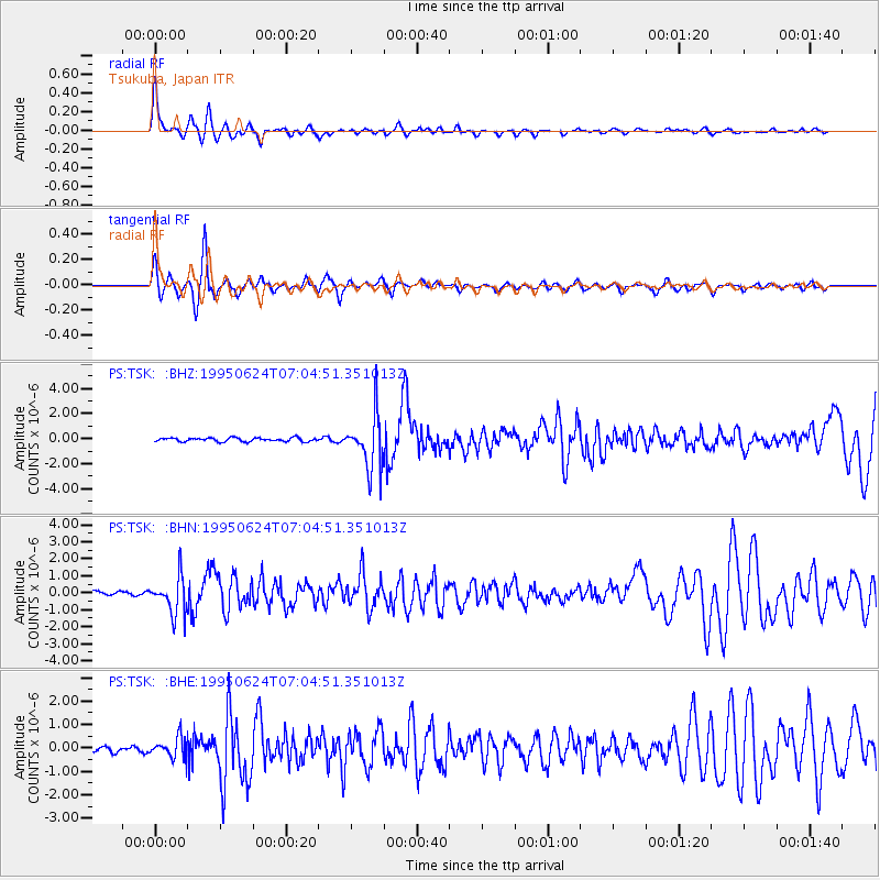
Signal To Noise
| Channel | StoN | STA | LTA |
| PS:TSK: :BHN:19950624T07:04:51.351013Z | 8.675904 | 1.0855154E-6 | 1.251184E-7 |
| PS:TSK: :BHE:19950624T07:04:51.351013Z | 3.4459944 | 4.332135E-7 | 1.2571509E-7 |
| PS:TSK: :BHZ:19950624T07:04:51.351013Z | 14.121558 | 2.1426724E-6 | 1.5173059E-7 |
| Arrivals |
| Ps | 5.6 SECOND |
| PpPs | 20 SECOND |
| PsPs/PpSs | 25 SECOND |


