You are here: Home > Network List > PS - Pacific21 Stations List
> Station TSK Tsukuba, Japan > Earthquake Result Viewer
TSK Tsukuba, Japan - Earthquake Result Viewer
| Earthquake location: |
Myanmar-China Border Region |
| Earthquake latitude/longitude: |
21.9/99.2 |
| Earthquake time(UTC): |
1995/07/11 (192) 21:46:39 GMT |
| Earthquake Depth: |
13 km |
| Earthquake Magnitude: |
6.1 MB, 7.2 MS, 6.9 UNKNOWN, 6.8 MW |
| Earthquake Catalog/Contributor: |
WHDF/NEIC |
|
| Network: |
PS Pacific21 |
| Station: |
TSK Tsukuba, Japan |
| Lat/Lon: |
36.21 N/140.11 E |
| Elevation: |
350 m |
|
| Distance: |
38.2 deg |
| Az: |
58.937 deg |
| Baz: |
259.558 deg |
| Ray Param: |
0.07567734 |
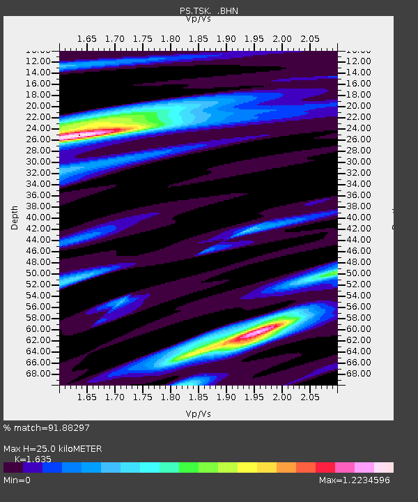
| Estimated Moho Depth: |
25.0 km |
| Estimated Crust Vp/Vs: |
1.63 |
| Assumed Crust Vp: |
6.24 km/s |
| Estimated Crust Vs: |
3.817 km/s |
| Estimated Crust Poisson's Ratio: |
0.20 |
|
| Radial Match: |
91.88297 % |
| Radial Bump: |
326 |
| Transverse Match: |
84.8192 % |
| Transverse Bump: |
400 |
| SOD ConfigId: |
6273 |
| Insert Time: |
2010-02-27 03:53:11.029 +0000 |
| GWidth: |
2.5 |
| Max Bumps: |
400 |
| Tol: |
0.001 |
|

Signal To Noise
| Channel | StoN | STA | LTA |
| PS:TSK: :BHN:19950711T21:53:28.40401Z | 2.21057 | 1.1881472E-7 | 5.3748455E-8 |
| PS:TSK: :BHE:19950711T21:53:28.40401Z | 4.7859273 | 2.9317476E-7 | 6.1257666E-8 |
| PS:TSK: :BHZ:19950711T21:53:28.40401Z | 6.693612 | 5.09896E-7 | 7.6176505E-8 |
| Arrivals |
| Ps | 2.7 SECOND |
| PpPs | 9.8 SECOND |
| PsPs/PpSs | 13 SECOND |


