You are here: Home > Network List > SC - New Mexico Tech Seismic Network Stations List
> Station Y22A Socorro, NM, USA > Earthquake Result Viewer
Y22A Socorro, NM, USA - Earthquake Result Viewer
| Earthquake location: |
South Of Fiji Islands |
| Earthquake latitude/longitude: |
-23.0/-177.2 |
| Earthquake time(UTC): |
2013/05/23 (143) 17:19:04 GMT |
| Earthquake Depth: |
174 km |
| Earthquake Magnitude: |
7.4 MW, 6.6 MB, 7.4 MW |
| Earthquake Catalog/Contributor: |
NEIC PDE/NEIC PDE-W |
|
| Network: |
SC New Mexico Tech Seismic Network |
| Station: |
Y22A Socorro, NM, USA |
| Lat/Lon: |
33.94 N/106.97 W |
| Elevation: |
1674 m |
|
| Distance: |
87.6 deg |
| Az: |
51.561 deg |
| Baz: |
240.235 deg |
| Ray Param: |
0.042842276 |
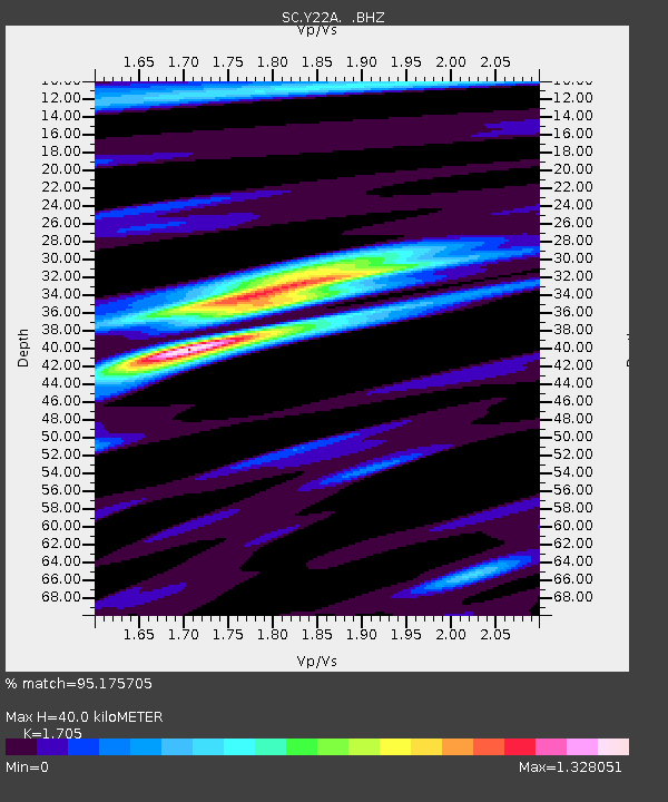
| Estimated Moho Depth: |
40.0 km |
| Estimated Crust Vp/Vs: |
1.71 |
| Assumed Crust Vp: |
6.502 km/s |
| Estimated Crust Vs: |
3.813 km/s |
| Estimated Crust Poisson's Ratio: |
0.24 |
|
| Radial Match: |
95.175705 % |
| Radial Bump: |
400 |
| Transverse Match: |
86.357574 % |
| Transverse Bump: |
400 |
| SOD ConfigId: |
512894 |
| Insert Time: |
2013-09-14 16:05:49.396 +0000 |
| GWidth: |
2.5 |
| Max Bumps: |
400 |
| Tol: |
0.001 |
|

Signal To Noise
| Channel | StoN | STA | LTA |
| SC:Y22A: :BHZ:20130523T17:31:01.799011Z | 9.2328825 | 1.7069385E-6 | 1.8487601E-7 |
| SC:Y22A: :BHN:20130523T17:31:01.799011Z | 2.2320664 | 3.6237768E-7 | 1.6235076E-7 |
| SC:Y22A: :BHE:20130523T17:31:01.799011Z | 2.4348009 | 4.5043467E-7 | 1.8499857E-7 |
| Arrivals |
| Ps | 4.4 SECOND |
| PpPs | 16 SECOND |
| PsPs/PpSs | 21 SECOND |


