You are here: Home > Network List > TA - USArray Transportable Network (new EarthScope stations) Stations List
> Station BGNE Belgrade, NE, USA > Earthquake Result Viewer
BGNE Belgrade, NE, USA - Earthquake Result Viewer
| Earthquake location: |
South Of Fiji Islands |
| Earthquake latitude/longitude: |
-23.0/-177.2 |
| Earthquake time(UTC): |
2013/05/23 (143) 17:19:04 GMT |
| Earthquake Depth: |
174 km |
| Earthquake Magnitude: |
7.4 MW, 6.6 MB, 7.4 MW |
| Earthquake Catalog/Contributor: |
NEIC PDE/NEIC PDE-W |
|
| Network: |
TA USArray Transportable Network (new EarthScope stations) |
| Station: |
BGNE Belgrade, NE, USA |
| Lat/Lon: |
41.41 N/98.15 W |
| Elevation: |
573 m |
|
| Distance: |
97.2 deg |
| Az: |
48.109 deg |
| Baz: |
245.76 deg |
| Ray Param: |
0.040143818 |
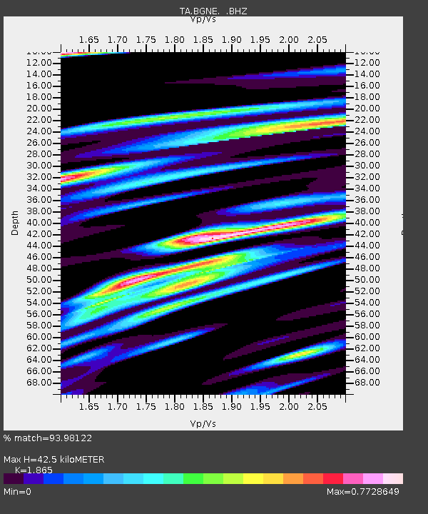
| Estimated Moho Depth: |
42.5 km |
| Estimated Crust Vp/Vs: |
1.87 |
| Assumed Crust Vp: |
6.53 km/s |
| Estimated Crust Vs: |
3.502 km/s |
| Estimated Crust Poisson's Ratio: |
0.30 |
|
| Radial Match: |
93.98122 % |
| Radial Bump: |
400 |
| Transverse Match: |
82.06301 % |
| Transverse Bump: |
400 |
| SOD ConfigId: |
512894 |
| Insert Time: |
2013-09-14 16:06:29.295 +0000 |
| GWidth: |
2.5 |
| Max Bumps: |
400 |
| Tol: |
0.001 |
|

Signal To Noise
| Channel | StoN | STA | LTA |
| TA:BGNE: :BHZ:20130523T17:31:45.875Z | 6.1628356 | 8.312178E-7 | 1.3487586E-7 |
| TA:BGNE: :BHN:20130523T17:31:45.875Z | 1.338205 | 2.8735943E-7 | 2.1473498E-7 |
| TA:BGNE: :BHE:20130523T17:31:45.875Z | 1.3352834 | 3.2480648E-7 | 2.4324908E-7 |
| Arrivals |
| Ps | 5.7 SECOND |
| PpPs | 18 SECOND |
| PsPs/PpSs | 24 SECOND |


