You are here: Home > Network List > TA - USArray Transportable Network (new EarthScope stations) Stations List
> Station H04D Lebanon, OR, USA > Earthquake Result Viewer
H04D Lebanon, OR, USA - Earthquake Result Viewer
| Earthquake location: |
South Of Fiji Islands |
| Earthquake latitude/longitude: |
-23.0/-177.2 |
| Earthquake time(UTC): |
2013/05/23 (143) 17:19:04 GMT |
| Earthquake Depth: |
174 km |
| Earthquake Magnitude: |
7.4 MW, 6.6 MB, 7.4 MW |
| Earthquake Catalog/Contributor: |
NEIC PDE/NEIC PDE-W |
|
| Network: |
TA USArray Transportable Network (new EarthScope stations) |
| Station: |
H04D Lebanon, OR, USA |
| Lat/Lon: |
44.52 N/122.74 W |
| Elevation: |
284 m |
|
| Distance: |
83.6 deg |
| Az: |
35.869 deg |
| Baz: |
229.003 deg |
| Ray Param: |
0.04565359 |
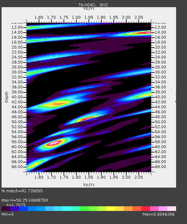
| Estimated Moho Depth: |
58.25 km |
| Estimated Crust Vp/Vs: |
1.71 |
| Assumed Crust Vp: |
6.566 km/s |
| Estimated Crust Vs: |
3.845 km/s |
| Estimated Crust Poisson's Ratio: |
0.24 |
|
| Radial Match: |
91.735855 % |
| Radial Bump: |
400 |
| Transverse Match: |
85.03591 % |
| Transverse Bump: |
400 |
| SOD ConfigId: |
512894 |
| Insert Time: |
2013-09-14 16:07:11.914 +0000 |
| GWidth: |
2.5 |
| Max Bumps: |
400 |
| Tol: |
0.001 |
|

Signal To Noise
| Channel | StoN | STA | LTA |
| TA:H04D: :BHZ:20130523T17:30:42.424988Z | 5.9333205 | 2.9574903E-6 | 4.984545E-7 |
| TA:H04D: :BHN:20130523T17:30:42.424988Z | 1.6769242 | 8.4728896E-7 | 5.0526376E-7 |
| TA:H04D: :BHE:20130523T17:30:42.424988Z | 2.2395015 | 1.2382861E-6 | 5.529294E-7 |
| Arrivals |
| Ps | 6.4 SECOND |
| PpPs | 23 SECOND |
| PsPs/PpSs | 30 SECOND |


