You are here: Home > Network List > TA - USArray Transportable Network (new EarthScope stations) Stations List
> Station L04D Klamath Falls, OR, USA > Earthquake Result Viewer
L04D Klamath Falls, OR, USA - Earthquake Result Viewer

| Earthquake location: |
South Of Fiji Islands |
| Earthquake latitude/longitude: |
-23.0/-177.2 |
| Earthquake time(UTC): |
2013/05/23 (143) 17:19:04 GMT |
| Earthquake Depth: |
174 km |
| Earthquake Magnitude: |
7.4 MW, 6.6 MB, 7.4 MW |
| Earthquake Catalog/Contributor: |
NEIC PDE/NEIC PDE-W |
|
| Network: |
TA USArray Transportable Network (new EarthScope stations) |
| Station: |
L04D Klamath Falls, OR, USA |
| Lat/Lon: |
42.22 N/122.30 W |
| Elevation: |
1437 m |
|
| Distance: |
82.4 deg |
| Az: |
37.837 deg |
| Baz: |
229.539 deg |
| Ray Param: |
0.04653522 |
| Estimated Moho Depth: |
33.5 km |
| Estimated Crust Vp/Vs: |
1.88 |
| Assumed Crust Vp: |
6.522 km/s |
| Estimated Crust Vs: |
3.478 km/s |
| Estimated Crust Poisson's Ratio: |
0.30 |
|
| Radial Match: |
87.76463 % |
| Radial Bump: |
400 |
| Transverse Match: |
82.977745 % |
| Transverse Bump: |
400 |
| SOD ConfigId: |
512894 |
| Insert Time: |
2013-09-14 16:08:10.340 +0000 |
| GWidth: |
2.5 |
| Max Bumps: |
400 |
| Tol: |
0.001 |
|
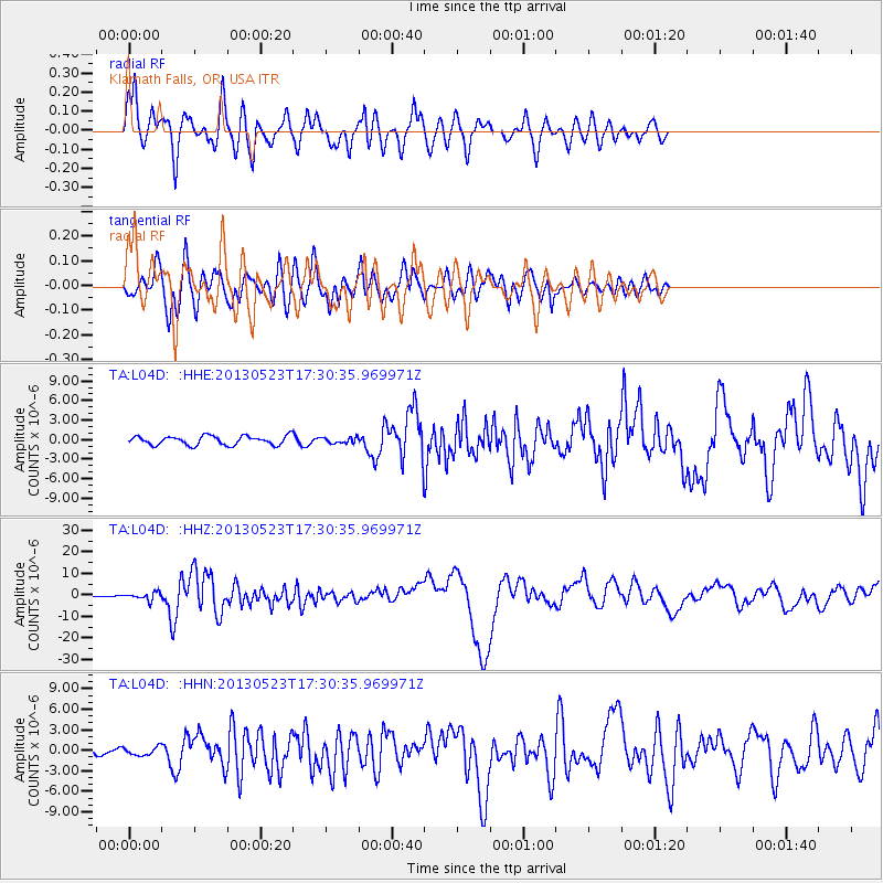
Signal To Noise
| Channel | StoN | STA | LTA |
| TA:L04D: :HHZ:20130523T17:30:35.969971Z | 4.9595003 | 1.7711527E-6 | 3.571232E-7 |
| TA:L04D: :HHN:20130523T17:30:35.969971Z | 1.7355759 | 5.9943665E-7 | 3.45382E-7 |
| TA:L04D: :HHE:20130523T17:30:35.969971Z | 0.6501732 | 4.4692172E-7 | 6.873887E-7 |
| Arrivals |
| Ps | 4.6 SECOND |
| PpPs | 14 SECOND |
| PsPs/PpSs | 19 SECOND |


