TSK Tsukuba, Japan - Earthquake Result Viewer
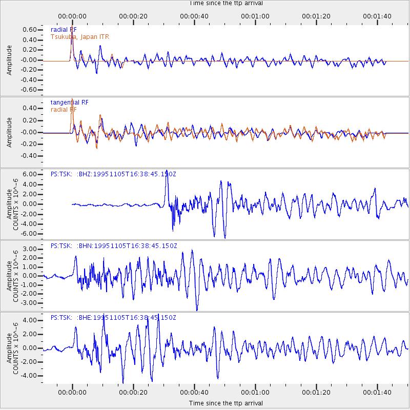
Earthquake location: Southern Sumatra, Indonesia
Earthquake latitude/longitude: -4.9/103.2
Earthquake time(UTC): 1995/11/05 (309) 16:30:00 GMT
Earthquake Depth: 58 km
Earthquake Magnitude: 6.3 MB, 6.1 MS, 5.9 UNKNOWN, 6.3 MW
Earthquake Catalog/Contributor: WHDF/NEIC
Network: PS Pacific21
Station: TSK Tsukuba, Japan
Lat/Lon: 36.21 N/140.11 E
Elevation: 350 m
Distance: 53.5 deg
Az: 37.12 deg
Baz: 228.028 deg
Ray Param: 0.065876365
Estimated Moho Depth: 22.0 km
Estimated Crust Vp/Vs: 1.76
Assumed Crust Vp: 6.24 km/s
Estimated Crust Vs: 3.54 km/s
Estimated Crust Poisson's Ratio: 0.26
Radial Match: 82.60164 %
Radial Bump: 400
Transverse Match: 83.96347 %
Transverse Bump: 400
SOD ConfigId: 6273
Insert Time: 2010-02-27 03:53:24.935 +0000
GWidth: 2.5
Max Bumps: 400
Tol: 0.001

Signal To Noise

ChannelStoNSTALTA
PS:TSK: :BHN:19951105T16:38:45.150Z5.90561639.4283587E-71.5965071E-7
PS:TSK: :BHE:19951105T16:38:45.150Z6.1360991.1828342E-61.9276649E-7
PS:TSK: :BHZ:19951105T16:38:45.150Z19.4245832.7955962E-61.4392052E-7
Arrivals
Ps2.8 SECOND
PpPs9.3 SECOND
PsPs/PpSs12 SECOND