You are here: Home > Network List > TA - USArray Transportable Network (new EarthScope stations) Stations List
> Station O03E Paynes Creek, CA, USA > Earthquake Result Viewer
O03E Paynes Creek, CA, USA - Earthquake Result Viewer
| Earthquake location: |
South Of Fiji Islands |
| Earthquake latitude/longitude: |
-23.0/-177.2 |
| Earthquake time(UTC): |
2013/05/23 (143) 17:19:04 GMT |
| Earthquake Depth: |
174 km |
| Earthquake Magnitude: |
7.4 MW, 6.6 MB, 7.4 MW |
| Earthquake Catalog/Contributor: |
NEIC PDE/NEIC PDE-W |
|
| Network: |
TA USArray Transportable Network (new EarthScope stations) |
| Station: |
O03E Paynes Creek, CA, USA |
| Lat/Lon: |
40.29 N/121.80 W |
| Elevation: |
967 m |
|
| Distance: |
81.4 deg |
| Az: |
39.567 deg |
| Baz: |
230.114 deg |
| Ray Param: |
0.04718875 |
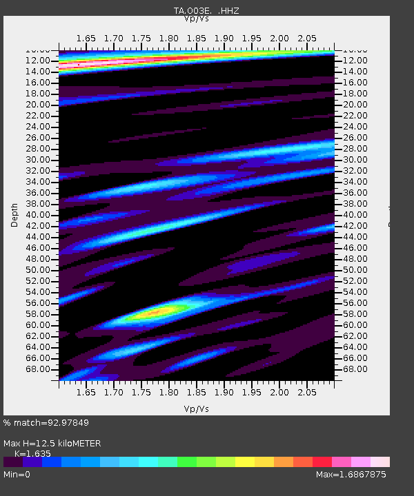
| Estimated Moho Depth: |
12.5 km |
| Estimated Crust Vp/Vs: |
1.63 |
| Assumed Crust Vp: |
6.566 km/s |
| Estimated Crust Vs: |
4.016 km/s |
| Estimated Crust Poisson's Ratio: |
0.20 |
|
| Radial Match: |
92.97849 % |
| Radial Bump: |
385 |
| Transverse Match: |
91.69611 % |
| Transverse Bump: |
396 |
| SOD ConfigId: |
512894 |
| Insert Time: |
2013-09-14 16:08:36.202 +0000 |
| GWidth: |
2.5 |
| Max Bumps: |
400 |
| Tol: |
0.001 |
|
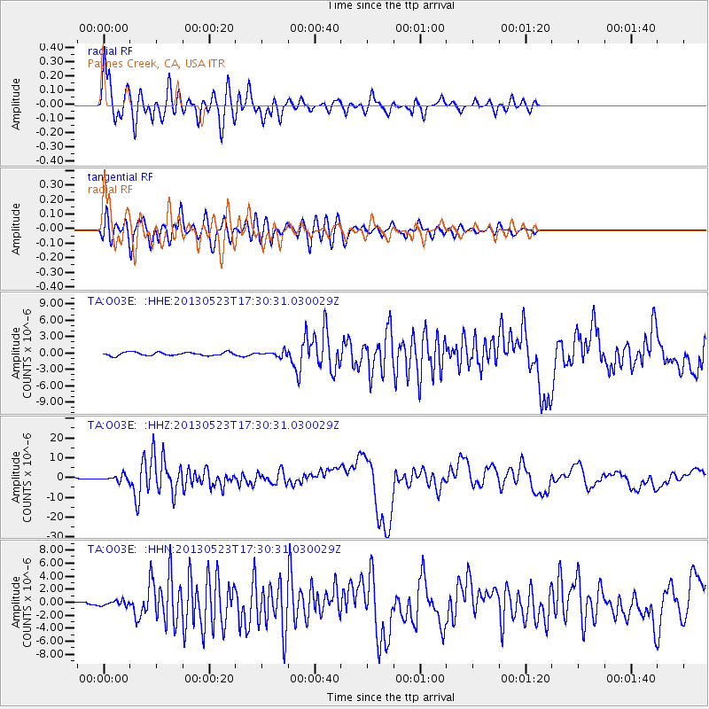
Signal To Noise
| Channel | StoN | STA | LTA |
| TA:O03E: :HHZ:20130523T17:30:31.030029Z | 7.4425526 | 1.5162126E-6 | 2.0372211E-7 |
| TA:O03E: :HHN:20130523T17:30:31.030029Z | 1.9631462 | 4.0778622E-7 | 2.0772075E-7 |
| TA:O03E: :HHE:20130523T17:30:31.030029Z | 1.5312915 | 4.660759E-7 | 3.0436786E-7 |
| Arrivals |
| Ps | 1.2 SECOND |
| PpPs | 4.9 SECOND |
| PsPs/PpSs | 6.1 SECOND |


