You are here: Home > Network List > PS - Pacific21 Stations List
> Station TSK Tsukuba, Japan > Earthquake Result Viewer
TSK Tsukuba, Japan - Earthquake Result Viewer
| Earthquake location: |
Banda Sea |
| Earthquake latitude/longitude: |
-6.9/129.2 |
| Earthquake time(UTC): |
1995/12/25 (359) 04:43:24 GMT |
| Earthquake Depth: |
150 km |
| Earthquake Magnitude: |
6.2 MB, 7.1 UNKNOWN, 7.1 MW |
| Earthquake Catalog/Contributor: |
WHDF/NEIC |
|
| Network: |
PS Pacific21 |
| Station: |
TSK Tsukuba, Japan |
| Lat/Lon: |
36.21 N/140.11 E |
| Elevation: |
350 m |
|
| Distance: |
44.1 deg |
| Az: |
12.722 deg |
| Baz: |
195.684 deg |
| Ray Param: |
0.071562976 |
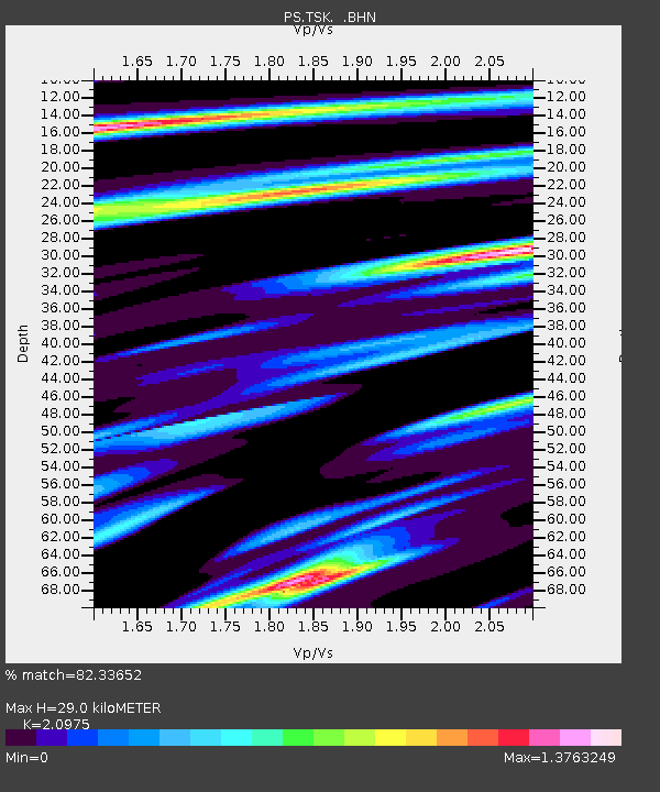
| Estimated Moho Depth: |
29.0 km |
| Estimated Crust Vp/Vs: |
2.10 |
| Assumed Crust Vp: |
6.24 km/s |
| Estimated Crust Vs: |
2.975 km/s |
| Estimated Crust Poisson's Ratio: |
0.35 |
|
| Radial Match: |
82.33652 % |
| Radial Bump: |
400 |
| Transverse Match: |
69.12853 % |
| Transverse Bump: |
400 |
| SOD ConfigId: |
6273 |
| Insert Time: |
2010-02-27 03:53:26.346 +0000 |
| GWidth: |
2.5 |
| Max Bumps: |
400 |
| Tol: |
0.001 |
|

Signal To Noise
| Channel | StoN | STA | LTA |
| PS:TSK: :BHN:19951225T04:50:48.000006Z | 1.215478 | 1.2001623E-6 | 9.873994E-7 |
| PS:TSK: :BHE:19951225T04:50:48.000006Z | 1.1194645 | 1.1047266E-6 | 9.86835E-7 |
| PS:TSK: :BHZ:19951225T04:50:48.000006Z | 1.7363219 | 2.0738312E-6 | 1.1943818E-6 |
| Arrivals |
| Ps | 5.4 SECOND |
| PpPs | 14 SECOND |
| PsPs/PpSs | 19 SECOND |


