You are here: Home > Network List > PS - Pacific21 Stations List
> Station TSK Tsukuba, Japan > Earthquake Result Viewer
TSK Tsukuba, Japan - Earthquake Result Viewer
| Earthquake location: |
Fiji Islands Region |
| Earthquake latitude/longitude: |
-21.2/-176.6 |
| Earthquake time(UTC): |
1996/11/14 (319) 13:47:38 GMT |
| Earthquake Depth: |
192 km |
| Earthquake Magnitude: |
5.9 MB, 6.2 UNKNOWN, 6.1 MW |
| Earthquake Catalog/Contributor: |
WHDF/NEIC |
|
| Network: |
PS Pacific21 |
| Station: |
TSK Tsukuba, Japan |
| Lat/Lon: |
36.21 N/140.11 E |
| Elevation: |
350 m |
|
| Distance: |
70.3 deg |
| Az: |
323.921 deg |
| Baz: |
137.21 deg |
| Ray Param: |
0.054558717 |
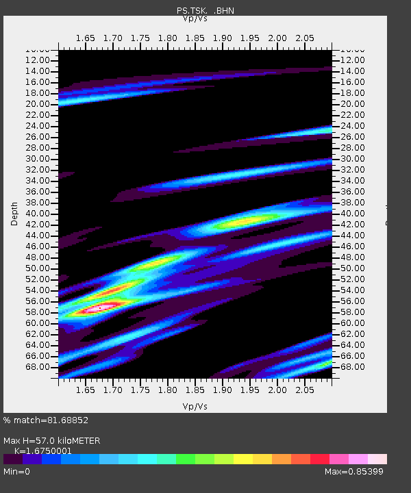
| Estimated Moho Depth: |
57.0 km |
| Estimated Crust Vp/Vs: |
1.68 |
| Assumed Crust Vp: |
6.24 km/s |
| Estimated Crust Vs: |
3.725 km/s |
| Estimated Crust Poisson's Ratio: |
0.22 |
|
| Radial Match: |
81.68852 % |
| Radial Bump: |
344 |
| Transverse Match: |
43.910114 % |
| Transverse Bump: |
400 |
| SOD ConfigId: |
6273 |
| Insert Time: |
2010-02-27 03:53:28.278 +0000 |
| GWidth: |
2.5 |
| Max Bumps: |
400 |
| Tol: |
0.001 |
|

Signal To Noise
| Channel | StoN | STA | LTA |
| PS:TSK: :BHN:19961114T13:57:59.503015Z | 1.0955826 | 7.9522204E-7 | 7.2584396E-7 |
| PS:TSK: :BHE:19961114T13:57:59.503015Z | 0.77149826 | 4.2870028E-7 | 5.556724E-7 |
| PS:TSK: :BHZ:19961114T13:57:59.503015Z | 2.3238354 | 1.7614751E-6 | 7.580034E-7 |
| Arrivals |
| Ps | 6.4 SECOND |
| PpPs | 24 SECOND |
| PsPs/PpSs | 30 SECOND |


