You are here: Home > Network List > PS - Pacific21 Stations List
> Station TSK Tsukuba, Japan > Earthquake Result Viewer
TSK Tsukuba, Japan - Earthquake Result Viewer
| Earthquake location: |
Kermadec Islands Region |
| Earthquake latitude/longitude: |
-31.2/180.0 |
| Earthquake time(UTC): |
1996/11/05 (310) 09:41:34 GMT |
| Earthquake Depth: |
369 km |
| Earthquake Magnitude: |
5.9 MB, 6.8 UNKNOWN, 6.7 MW |
| Earthquake Catalog/Contributor: |
WHDF/NEIC |
|
| Network: |
PS Pacific21 |
| Station: |
TSK Tsukuba, Japan |
| Lat/Lon: |
36.21 N/140.11 E |
| Elevation: |
350 m |
|
| Distance: |
76.8 deg |
| Az: |
327.805 deg |
| Baz: |
145.613 deg |
| Ray Param: |
0.049733143 |
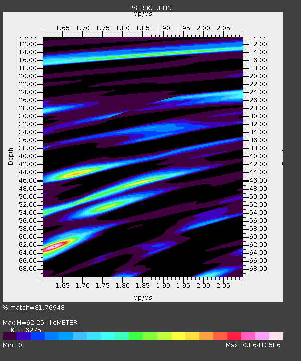
| Estimated Moho Depth: |
62.25 km |
| Estimated Crust Vp/Vs: |
1.63 |
| Assumed Crust Vp: |
6.24 km/s |
| Estimated Crust Vs: |
3.834 km/s |
| Estimated Crust Poisson's Ratio: |
0.20 |
|
| Radial Match: |
81.76948 % |
| Radial Bump: |
400 |
| Transverse Match: |
72.39693 % |
| Transverse Bump: |
400 |
| SOD ConfigId: |
6273 |
| Insert Time: |
2010-02-27 03:53:30.180 +0000 |
| GWidth: |
2.5 |
| Max Bumps: |
400 |
| Tol: |
0.001 |
|
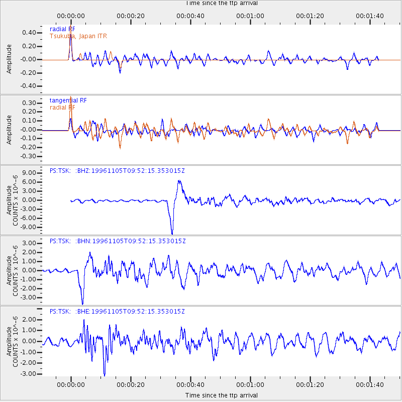
Signal To Noise
| Channel | StoN | STA | LTA |
| PS:TSK: :BHN:19961105T09:52:15.353015Z | 10.553998 | 1.3988574E-6 | 1.325429E-7 |
| PS:TSK: :BHE:19961105T09:52:15.353015Z | 2.1583257 | 6.01994E-7 | 2.7891713E-7 |
| PS:TSK: :BHZ:19961105T09:52:15.353015Z | 15.07477 | 4.2736106E-6 | 2.8349424E-7 |
| Arrivals |
| Ps | 6.5 SECOND |
| PpPs | 25 SECOND |
| PsPs/PpSs | 32 SECOND |


