You are here: Home > Network List > US - United States National Seismic Network Stations List
> Station NATX Nacogdoches, Texas, USA > Earthquake Result Viewer
NATX Nacogdoches, Texas, USA - Earthquake Result Viewer
*The percent match for this event was below the threshold and hence no stack was calculated.
| Earthquake location: |
South Of Fiji Islands |
| Earthquake latitude/longitude: |
-23.0/-177.2 |
| Earthquake time(UTC): |
2013/05/23 (143) 17:19:04 GMT |
| Earthquake Depth: |
174 km |
| Earthquake Magnitude: |
7.4 MW, 6.6 MB, 7.4 MW |
| Earthquake Catalog/Contributor: |
NEIC PDE/NEIC PDE-W |
|
| Network: |
US United States National Seismic Network |
| Station: |
NATX Nacogdoches, Texas, USA |
| Lat/Lon: |
31.76 N/94.66 W |
| Elevation: |
156 m |
|
| Distance: |
95.9 deg |
| Az: |
58.117 deg |
| Baz: |
246.7 deg |
| Ray Param: |
$rayparam |
*The percent match for this event was below the threshold and hence was not used in the summary stack. |
|
| Radial Match: |
95.832405 % |
| Radial Bump: |
400 |
| Transverse Match: |
85.58864 % |
| Transverse Bump: |
400 |
| SOD ConfigId: |
512894 |
| Insert Time: |
2013-09-14 16:10:45.224 +0000 |
| GWidth: |
2.5 |
| Max Bumps: |
400 |
| Tol: |
0.001 |
|
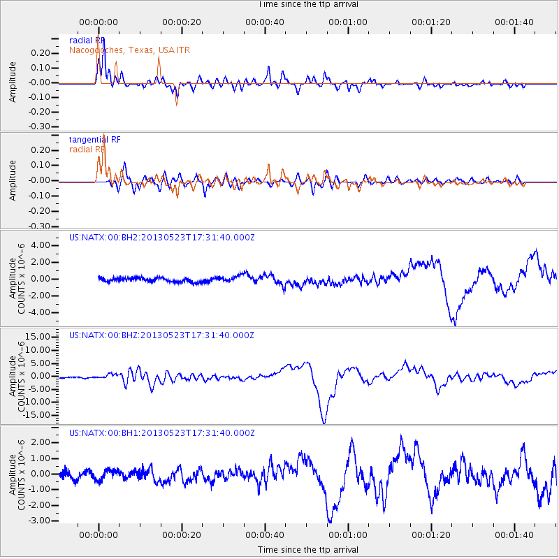
Signal To Noise
| Channel | StoN | STA | LTA |
| US:NATX:00:BHZ:20130523T17:31:40.000Z | 6.0746136 | 9.082923E-7 | 1.4952265E-7 |
| US:NATX:00:BH1:20130523T17:31:40.000Z | 1.408671 | 3.2480204E-7 | 2.3057339E-7 |
| US:NATX:00:BH2:20130523T17:31:40.000Z | 1.6313008 | 4.03882E-7 | 2.475828E-7 |
| Arrivals |
| Ps | |
| PpPs | |
| PsPs/PpSs | |


