You are here: Home > Network List > US - United States National Seismic Network Stations List
> Station NLWA Neilton Lookout, Washington, USA > Earthquake Result Viewer
NLWA Neilton Lookout, Washington, USA - Earthquake Result Viewer
| Earthquake location: |
South Of Fiji Islands |
| Earthquake latitude/longitude: |
-23.0/-177.2 |
| Earthquake time(UTC): |
2013/05/23 (143) 17:19:04 GMT |
| Earthquake Depth: |
174 km |
| Earthquake Magnitude: |
7.4 MW, 6.6 MB, 7.4 MW |
| Earthquake Catalog/Contributor: |
NEIC PDE/NEIC PDE-W |
|
| Network: |
US United States National Seismic Network |
| Station: |
NLWA Neilton Lookout, Washington, USA |
| Lat/Lon: |
47.39 N/123.87 W |
| Elevation: |
640 m |
|
| Distance: |
84.9 deg |
| Az: |
33.185 deg |
| Baz: |
227.924 deg |
| Ray Param: |
0.044723988 |
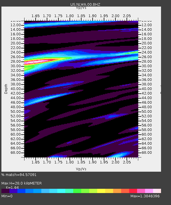
| Estimated Moho Depth: |
28.0 km |
| Estimated Crust Vp/Vs: |
1.64 |
| Assumed Crust Vp: |
6.566 km/s |
| Estimated Crust Vs: |
4.004 km/s |
| Estimated Crust Poisson's Ratio: |
0.20 |
|
| Radial Match: |
94.57091 % |
| Radial Bump: |
400 |
| Transverse Match: |
82.96568 % |
| Transverse Bump: |
400 |
| SOD ConfigId: |
512894 |
| Insert Time: |
2013-09-14 16:10:51.046 +0000 |
| GWidth: |
2.5 |
| Max Bumps: |
400 |
| Tol: |
0.001 |
|

Signal To Noise
| Channel | StoN | STA | LTA |
| US:NLWA:00:BHZ:20130523T17:30:49.000Z | 6.0685973 | 2.2750328E-6 | 3.7488607E-7 |
| US:NLWA:00:BH1:20130523T17:30:49.000Z | 1.704043 | 8.0867846E-7 | 4.745646E-7 |
| US:NLWA:00:BH2:20130523T17:30:49.000Z | 1.0446745 | 4.093541E-7 | 3.9184843E-7 |
| Arrivals |
| Ps | 2.8 SECOND |
| PpPs | 11 SECOND |
| PsPs/PpSs | 14 SECOND |


