You are here: Home > Network List > UU - University of Utah Regional Network Stations List
> Station CVRU Castle Valley Ranch, Emery, UT, USA old TA-Q16A > Earthquake Result Viewer
CVRU Castle Valley Ranch, Emery, UT, USA old TA-Q16A - Earthquake Result Viewer
| Earthquake location: |
South Of Fiji Islands |
| Earthquake latitude/longitude: |
-23.0/-177.2 |
| Earthquake time(UTC): |
2013/05/23 (143) 17:19:04 GMT |
| Earthquake Depth: |
174 km |
| Earthquake Magnitude: |
7.4 MW, 6.6 MB, 7.4 MW |
| Earthquake Catalog/Contributor: |
NEIC PDE/NEIC PDE-W |
|
| Network: |
UU University of Utah Regional Network |
| Station: |
CVRU Castle Valley Ranch, Emery, UT, USA old TA-Q16A |
| Lat/Lon: |
38.92 N/111.17 W |
| Elevation: |
1912 m |
|
| Distance: |
87.2 deg |
| Az: |
45.548 deg |
| Baz: |
237.47 deg |
| Ray Param: |
0.043088473 |
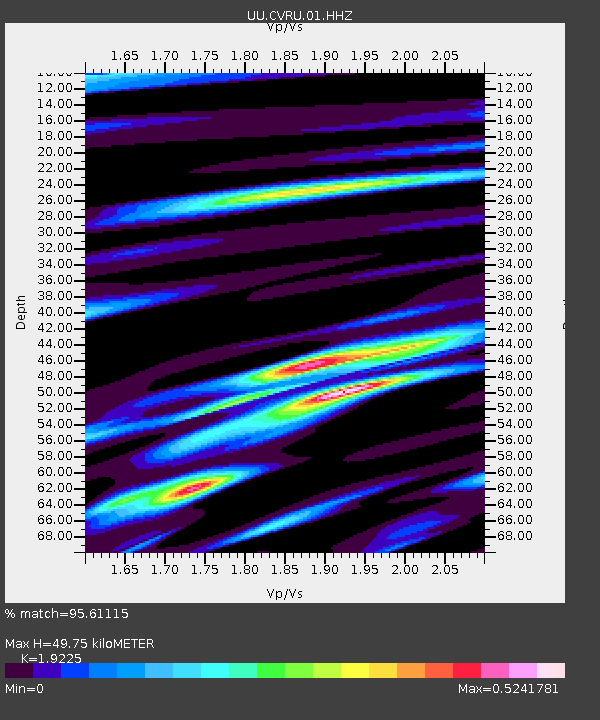
| Estimated Moho Depth: |
49.75 km |
| Estimated Crust Vp/Vs: |
1.92 |
| Assumed Crust Vp: |
6.207 km/s |
| Estimated Crust Vs: |
3.228 km/s |
| Estimated Crust Poisson's Ratio: |
0.31 |
|
| Radial Match: |
95.61115 % |
| Radial Bump: |
377 |
| Transverse Match: |
85.85372 % |
| Transverse Bump: |
400 |
| SOD ConfigId: |
512894 |
| Insert Time: |
2013-09-14 16:11:41.791 +0000 |
| GWidth: |
2.5 |
| Max Bumps: |
400 |
| Tol: |
0.001 |
|
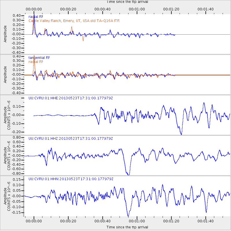
Signal To Noise
| Channel | StoN | STA | LTA |
| UU:CVRU:01:HHZ:20130523T17:31:00.177979Z | 6.9402843 | 2.4818819E-8 | 3.5760521E-9 |
| UU:CVRU:01:HHN:20130523T17:31:00.177979Z | 0.9075019 | 5.3466076E-9 | 5.8915663E-9 |
| UU:CVRU:01:HHE:20130523T17:31:00.177979Z | 1.1304225 | 3.873837E-9 | 3.426893E-9 |
| Arrivals |
| Ps | 7.5 SECOND |
| PpPs | 23 SECOND |
| PsPs/PpSs | 31 SECOND |


