You are here: Home > Network List > UU - University of Utah Regional Network Stations List
> Station HMU Henry Mountain, UT, USA > Earthquake Result Viewer
HMU Henry Mountain, UT, USA - Earthquake Result Viewer
| Earthquake location: |
South Of Fiji Islands |
| Earthquake latitude/longitude: |
-23.0/-177.2 |
| Earthquake time(UTC): |
2013/05/23 (143) 17:19:04 GMT |
| Earthquake Depth: |
174 km |
| Earthquake Magnitude: |
7.4 MW, 6.6 MB, 7.4 MW |
| Earthquake Catalog/Contributor: |
NEIC PDE/NEIC PDE-W |
|
| Network: |
UU University of Utah Regional Network |
| Station: |
HMU Henry Mountain, UT, USA |
| Lat/Lon: |
37.94 N/110.74 W |
| Elevation: |
2430 m |
|
| Distance: |
87.0 deg |
| Az: |
46.556 deg |
| Baz: |
237.787 deg |
| Ray Param: |
0.04326322 |
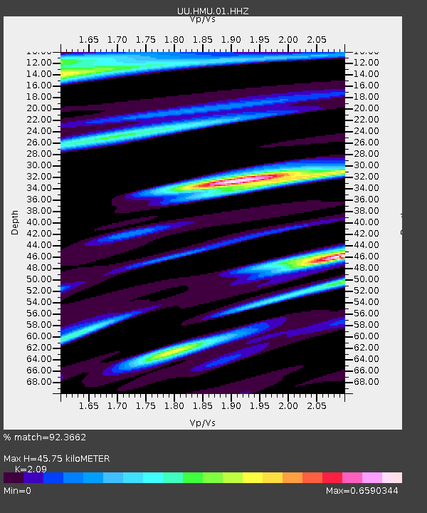
| Estimated Moho Depth: |
45.75 km |
| Estimated Crust Vp/Vs: |
2.09 |
| Assumed Crust Vp: |
6.247 km/s |
| Estimated Crust Vs: |
2.989 km/s |
| Estimated Crust Poisson's Ratio: |
0.35 |
|
| Radial Match: |
92.3662 % |
| Radial Bump: |
400 |
| Transverse Match: |
77.12986 % |
| Transverse Bump: |
400 |
| SOD ConfigId: |
512894 |
| Insert Time: |
2013-09-14 16:11:42.343 +0000 |
| GWidth: |
2.5 |
| Max Bumps: |
400 |
| Tol: |
0.001 |
|

Signal To Noise
| Channel | StoN | STA | LTA |
| UU:HMU:01:HHZ:20130523T17:30:59.031982Z | 3.3879292 | 2.6370325E-8 | 7.783612E-9 |
| UU:HMU:01:HHN:20130523T17:30:59.031982Z | 1.7012107 | 1.0484779E-8 | 6.1631282E-9 |
| UU:HMU:01:HHE:20130523T17:30:59.031982Z | 1.3237636 | 1.0269125E-8 | 7.757522E-9 |
| Arrivals |
| Ps | 8.1 SECOND |
| PpPs | 22 SECOND |
| PsPs/PpSs | 30 SECOND |


