You are here: Home > Network List > UW - Pacific Northwest Regional Seismic Network Stations List
> Station SHUK Shuksan (Mt. Baker Ski Area), WA > Earthquake Result Viewer
SHUK Shuksan (Mt. Baker Ski Area), WA - Earthquake Result Viewer
| Earthquake location: |
South Of Fiji Islands |
| Earthquake latitude/longitude: |
-23.0/-177.2 |
| Earthquake time(UTC): |
2013/05/23 (143) 17:19:04 GMT |
| Earthquake Depth: |
174 km |
| Earthquake Magnitude: |
7.4 MW, 6.6 MB, 7.4 MW |
| Earthquake Catalog/Contributor: |
NEIC PDE/NEIC PDE-W |
|
| Network: |
UW Pacific Northwest Regional Seismic Network |
| Station: |
SHUK Shuksan (Mt. Baker Ski Area), WA |
| Lat/Lon: |
48.85 N/121.68 W |
| Elevation: |
1516 m |
|
| Distance: |
87.0 deg |
| Az: |
33.055 deg |
| Baz: |
229.542 deg |
| Ray Param: |
0.04325311 |
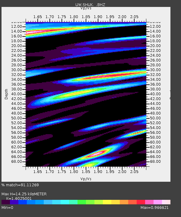
| Estimated Moho Depth: |
14.25 km |
| Estimated Crust Vp/Vs: |
1.60 |
| Assumed Crust Vp: |
6.566 km/s |
| Estimated Crust Vs: |
4.097 km/s |
| Estimated Crust Poisson's Ratio: |
0.18 |
|
| Radial Match: |
91.11269 % |
| Radial Bump: |
400 |
| Transverse Match: |
85.040184 % |
| Transverse Bump: |
400 |
| SOD ConfigId: |
512894 |
| Insert Time: |
2013-09-14 16:14:03.389 +0000 |
| GWidth: |
2.5 |
| Max Bumps: |
400 |
| Tol: |
0.001 |
|

Signal To Noise
| Channel | StoN | STA | LTA |
| UW:SHUK: :BHZ:20130523T17:30:59.119995Z | 8.147747 | 4.34109E-6 | 5.327963E-7 |
| UW:SHUK: :BHN:20130523T17:30:59.119995Z | 1.6491697 | 7.7451597E-7 | 4.6963996E-7 |
| UW:SHUK: :BHE:20130523T17:30:59.119995Z | 0.72052497 | 9.961656E-7 | 1.3825553E-6 |
| Arrivals |
| Ps | 1.3 SECOND |
| PpPs | 5.5 SECOND |
| PsPs/PpSs | 6.8 SECOND |


