You are here: Home > Network List > UW - Pacific Northwest Regional Seismic Network Stations List
> Station TUCA Wood Farm, Starbuck, WA, USA > Earthquake Result Viewer
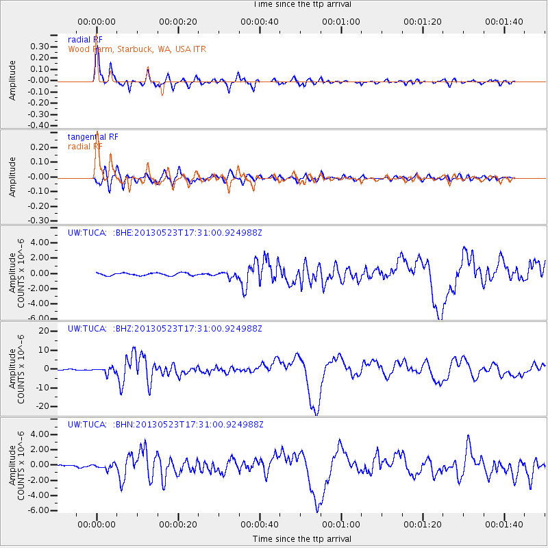
TUCA Wood Farm, Starbuck, WA, USA - Earthquake Result Viewer

| Earthquake location: |
South Of Fiji Islands |
| Earthquake latitude/longitude: |
-23.0/-177.2 |
| Earthquake time(UTC): |
2013/05/23 (143) 17:19:04 GMT |
| Earthquake Depth: |
174 km |
| Earthquake Magnitude: |
7.4 MW, 6.6 MB, 7.4 MW |
| Earthquake Catalog/Contributor: |
NEIC PDE/NEIC PDE-W |
|
| Network: |
UW Pacific Northwest Regional Seismic Network |
| Station: |
TUCA Wood Farm, Starbuck, WA, USA |
| Lat/Lon: |
46.51 N/118.15 W |
| Elevation: |
304 m |
|
| Distance: |
87.4 deg |
| Az: |
36.379 deg |
| Baz: |
232.31 deg |
| Ray Param: |
0.042975225 |
| Estimated Moho Depth: |
30.5 km |
| Estimated Crust Vp/Vs: |
1.72 |
| Assumed Crust Vp: |
6.419 km/s |
| Estimated Crust Vs: |
3.727 km/s |
| Estimated Crust Poisson's Ratio: |
0.25 |
|
| Radial Match: |
95.83937 % |
| Radial Bump: |
400 |
| Transverse Match: |
87.41771 % |
| Transverse Bump: |
400 |
| SOD ConfigId: |
512894 |
| Insert Time: |
2013-09-14 16:14:15.483 +0000 |
| GWidth: |
2.5 |
| Max Bumps: |
400 |
| Tol: |
0.001 |
|
Signal To Noise
| Channel | StoN | STA | LTA |
| UW:TUCA: :BHZ:20130523T17:31:00.924988Z | 8.118888 | 1.551054E-6 | 1.9104267E-7 |
| UW:TUCA: :BHN:20130523T17:31:00.924988Z | 2.9989917 | 3.2560772E-7 | 1.08572394E-7 |
| UW:TUCA: :BHE:20130523T17:31:00.924988Z | 2.0182228 | 3.456782E-7 | 1.7127851E-7 |
| Arrivals |
| Ps | 3.5 SECOND |
| PpPs | 13 SECOND |
| PsPs/PpSs | 16 SECOND |


