You are here: Home > Network List > PS - Pacific21 Stations List
> Station TSK Tsukuba, Japan > Earthquake Result Viewer
TSK Tsukuba, Japan - Earthquake Result Viewer
| Earthquake location: |
Irian Jaya Region, Indonesia |
| Earthquake latitude/longitude: |
-0.9/137.0 |
| Earthquake time(UTC): |
1996/02/17 (048) 05:59:29 GMT |
| Earthquake Depth: |
33 km |
| Earthquake Magnitude: |
6.5 MB, 8.1 MS, 7.9 UNKNOWN |
| Earthquake Catalog/Contributor: |
WHDF/NEIC |
|
| Network: |
PS Pacific21 |
| Station: |
TSK Tsukuba, Japan |
| Lat/Lon: |
36.21 N/140.11 E |
| Elevation: |
350 m |
|
| Distance: |
37.1 deg |
| Az: |
4.136 deg |
| Baz: |
185.116 deg |
| Ray Param: |
0.076268524 |
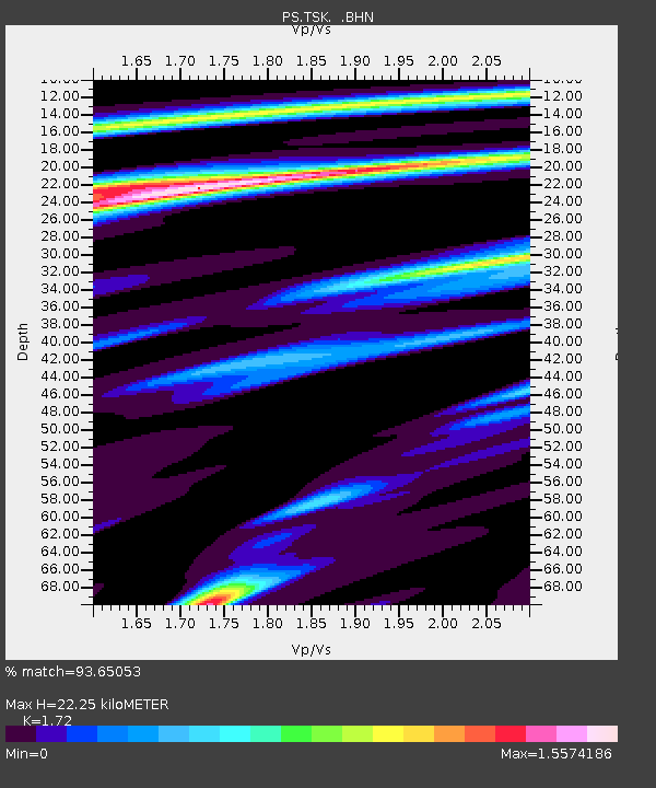
| Estimated Moho Depth: |
22.25 km |
| Estimated Crust Vp/Vs: |
1.72 |
| Assumed Crust Vp: |
6.24 km/s |
| Estimated Crust Vs: |
3.628 km/s |
| Estimated Crust Poisson's Ratio: |
0.24 |
|
| Radial Match: |
93.65053 % |
| Radial Bump: |
384 |
| Transverse Match: |
86.557236 % |
| Transverse Bump: |
400 |
| SOD ConfigId: |
6273 |
| Insert Time: |
2010-02-27 03:54:07.377 +0000 |
| GWidth: |
2.5 |
| Max Bumps: |
400 |
| Tol: |
0.001 |
|
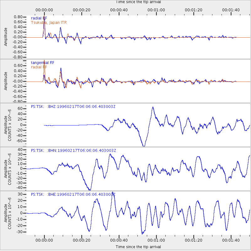
Signal To Noise
| Channel | StoN | STA | LTA |
| PS:TSK: :BHN:19960217T06:06:06.403003Z | 10.988328 | 5.594611E-6 | 5.091412E-7 |
| PS:TSK: :BHE:19960217T06:06:06.403003Z | 8.679666 | 2.915976E-6 | 3.3595487E-7 |
| PS:TSK: :BHZ:19960217T06:06:06.403003Z | 13.092392 | 1.0542654E-5 | 8.0525047E-7 |
| Arrivals |
| Ps | 2.8 SECOND |
| PpPs | 9.0 SECOND |
| PsPs/PpSs | 12 SECOND |


