You are here: Home > Network List > WY - Yellowstone Wyoming Seismic Network Stations List
> Station YTP The Promontory, YNP, WY, USA > Earthquake Result Viewer
YTP The Promontory, YNP, WY, USA - Earthquake Result Viewer
| Earthquake location: |
South Of Fiji Islands |
| Earthquake latitude/longitude: |
-23.0/-177.2 |
| Earthquake time(UTC): |
2013/05/23 (143) 17:19:04 GMT |
| Earthquake Depth: |
174 km |
| Earthquake Magnitude: |
7.4 MW, 6.6 MB, 7.4 MW |
| Earthquake Catalog/Contributor: |
NEIC PDE/NEIC PDE-W |
|
| Network: |
WY Yellowstone Wyoming Seismic Network |
| Station: |
YTP The Promontory, YNP, WY, USA |
| Lat/Lon: |
44.39 N/110.29 W |
| Elevation: |
2384 m |
|
| Distance: |
90.7 deg |
| Az: |
41.278 deg |
| Baz: |
237.981 deg |
| Ray Param: |
0.041617155 |
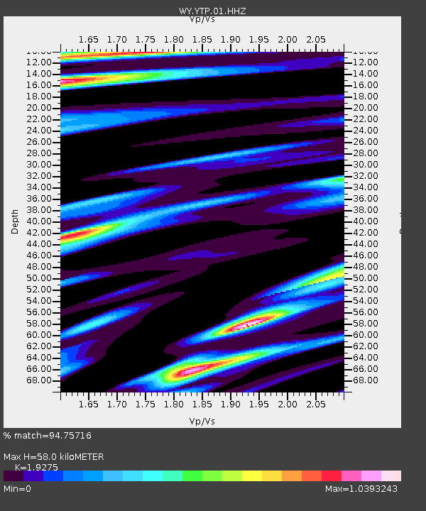
| Estimated Moho Depth: |
58.0 km |
| Estimated Crust Vp/Vs: |
1.93 |
| Assumed Crust Vp: |
6.35 km/s |
| Estimated Crust Vs: |
3.294 km/s |
| Estimated Crust Poisson's Ratio: |
0.32 |
|
| Radial Match: |
94.75716 % |
| Radial Bump: |
380 |
| Transverse Match: |
94.00833 % |
| Transverse Bump: |
400 |
| SOD ConfigId: |
512894 |
| Insert Time: |
2013-09-14 16:14:59.341 +0000 |
| GWidth: |
2.5 |
| Max Bumps: |
400 |
| Tol: |
0.001 |
|

Signal To Noise
| Channel | StoN | STA | LTA |
| WY:YTP:01:HHZ:20130523T17:31:16.458008Z | 4.7957096 | 2.1514442E-8 | 4.486185E-9 |
| WY:YTP:01:HHN:20130523T17:31:16.458008Z | 1.6539726 | 6.6790062E-9 | 4.03816E-9 |
| WY:YTP:01:HHE:20130523T17:31:16.458008Z | 2.4118738 | 7.984152E-9 | 3.3103524E-9 |
| Arrivals |
| Ps | 8.6 SECOND |
| PpPs | 26 SECOND |
| PsPs/PpSs | 35 SECOND |


