You are here: Home > Network List > PS - Pacific21 Stations List
> Station TSK Tsukuba, Japan > Earthquake Result Viewer
TSK Tsukuba, Japan - Earthquake Result Viewer

| Earthquake location: |
Southern Xinjiang, China |
| Earthquake latitude/longitude: |
40.0/76.7 |
| Earthquake time(UTC): |
1996/03/19 (079) 15:00:26 GMT |
| Earthquake Depth: |
28 km |
| Earthquake Magnitude: |
5.7 MB, 6.0 MS, 6.3 UNKNOWN, 6.1 MW |
| Earthquake Catalog/Contributor: |
WHDF/NEIC |
|
| Network: |
PS Pacific21 |
| Station: |
TSK Tsukuba, Japan |
| Lat/Lon: |
36.21 N/140.11 E |
| Elevation: |
350 m |
|
| Distance: |
49.1 deg |
| Az: |
73.069 deg |
| Baz: |
294.666 deg |
| Ray Param: |
0.06886099 |
| Estimated Moho Depth: |
24.75 km |
| Estimated Crust Vp/Vs: |
1.61 |
| Assumed Crust Vp: |
6.24 km/s |
| Estimated Crust Vs: |
3.87 km/s |
| Estimated Crust Poisson's Ratio: |
0.19 |
|
| Radial Match: |
83.67825 % |
| Radial Bump: |
400 |
| Transverse Match: |
72.80983 % |
| Transverse Bump: |
400 |
| SOD ConfigId: |
6273 |
| Insert Time: |
2010-02-27 03:54:15.900 +0000 |
| GWidth: |
2.5 |
| Max Bumps: |
400 |
| Tol: |
0.001 |
|
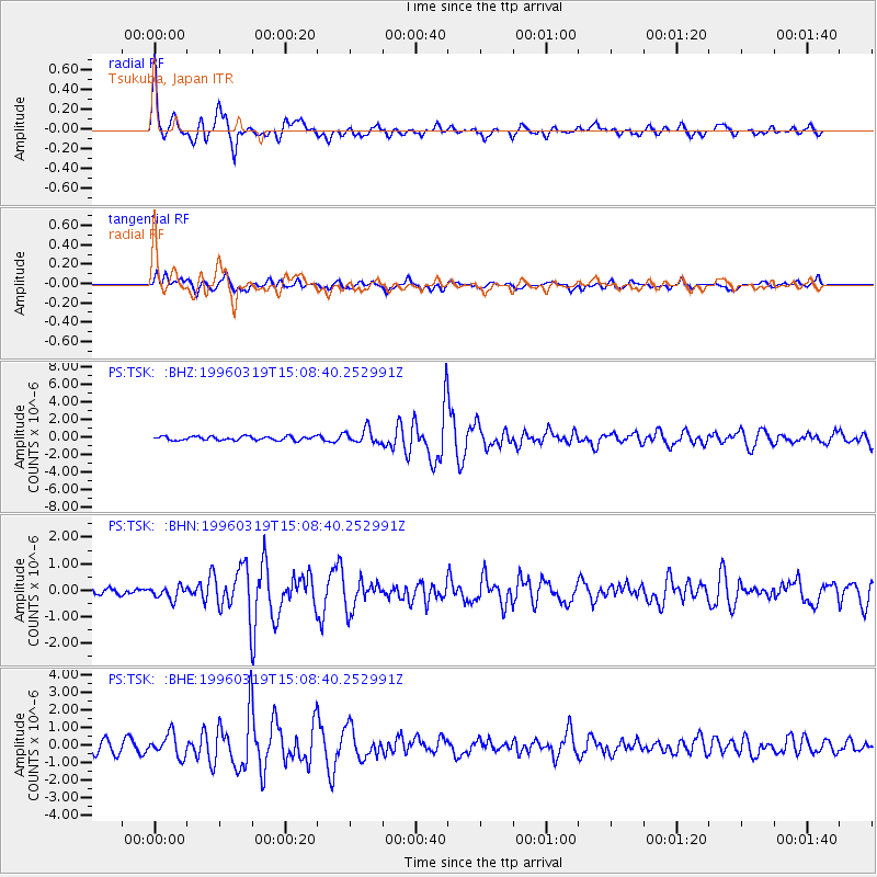
Signal To Noise
| Channel | StoN | STA | LTA |
| PS:TSK: :BHN:19960319T15:08:40.252991Z | 1.1422312 | 2.3304989E-7 | 2.0403039E-7 |
| PS:TSK: :BHE:19960319T15:08:40.252991Z | 2.0399725 | 6.4611305E-7 | 3.1672636E-7 |
| PS:TSK: :BHZ:19960319T15:08:40.252991Z | 3.7329838 | 8.1776574E-7 | 2.1906492E-7 |
| Arrivals |
| Ps | 2.6 SECOND |
| PpPs | 9.7 SECOND |
| PsPs/PpSs | 12 SECOND |


