You are here: Home > Network List > AU - Australian Seismological Centre Stations List
> Station KNRA Kunnunarra, Western Australia > Earthquake Result Viewer
KNRA Kunnunarra, Western Australia - Earthquake Result Viewer
| Earthquake location: |
Tonga Islands |
| Earthquake latitude/longitude: |
-20.6/-175.8 |
| Earthquake time(UTC): |
2013/05/23 (143) 21:07:46 GMT |
| Earthquake Depth: |
150 km |
| Earthquake Magnitude: |
6.3 MW, 5.7 MB, 6.3 MW |
| Earthquake Catalog/Contributor: |
NEIC PDE/NEIC PDE-W |
|
| Network: |
AU Australian Seismological Centre |
| Station: |
KNRA Kunnunarra, Western Australia |
| Lat/Lon: |
15.68 S/128.76 E |
| Elevation: |
101 m |
|
| Distance: |
52.7 deg |
| Az: |
265.615 deg |
| Baz: |
104.106 deg |
| Ray Param: |
0.066042684 |
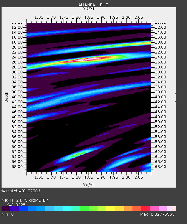
| Estimated Moho Depth: |
24.75 km |
| Estimated Crust Vp/Vs: |
1.83 |
| Assumed Crust Vp: |
6.397 km/s |
| Estimated Crust Vs: |
3.491 km/s |
| Estimated Crust Poisson's Ratio: |
0.29 |
|
| Radial Match: |
91.27086 % |
| Radial Bump: |
400 |
| Transverse Match: |
69.23271 % |
| Transverse Bump: |
400 |
| SOD ConfigId: |
512894 |
| Insert Time: |
2013-09-14 16:20:16.230 +0000 |
| GWidth: |
2.5 |
| Max Bumps: |
400 |
| Tol: |
0.001 |
|

Signal To Noise
| Channel | StoN | STA | LTA |
| AU:KNRA: :BHZ:20130523T21:16:15.269Z | 20.59542 | 4.803955E-6 | 2.3325357E-7 |
| AU:KNRA: :BHN:20130523T21:16:15.269Z | 1.7371714 | 3.8979655E-7 | 2.2438579E-7 |
| AU:KNRA: :BHE:20130523T21:16:15.269Z | 9.275683 | 2.2443014E-6 | 2.4195538E-7 |
| Arrivals |
| Ps | 3.4 SECOND |
| PpPs | 10 SECOND |
| PsPs/PpSs | 14 SECOND |


