You are here: Home > Network List > CN - Canadian National Seismograph Network Stations List
> Station INK INUVIK, NT > Earthquake Result Viewer
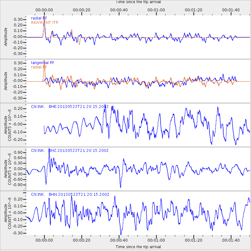
INK INUVIK, NT - Earthquake Result Viewer
*The percent match for this event was below the threshold and hence no stack was calculated.
| Earthquake location: |
Tonga Islands |
| Earthquake latitude/longitude: |
-20.6/-175.8 |
| Earthquake time(UTC): |
2013/05/23 (143) 21:07:46 GMT |
| Earthquake Depth: |
150 km |
| Earthquake Magnitude: |
6.3 MW, 5.7 MB, 6.3 MW |
| Earthquake Catalog/Contributor: |
NEIC PDE/NEIC PDE-W |
|
| Network: |
CN Canadian National Seismograph Network |
| Station: |
INK INUVIK, NT |
| Lat/Lon: |
68.31 N/133.53 W |
| Elevation: |
44 m |
|
| Distance: |
93.8 deg |
| Az: |
14.504 deg |
| Baz: |
219.137 deg |
| Ray Param: |
$rayparam |
*The percent match for this event was below the threshold and hence was not used in the summary stack. |
|
| Radial Match: |
51.455437 % |
| Radial Bump: |
389 |
| Transverse Match: |
59.171417 % |
| Transverse Bump: |
400 |
| SOD ConfigId: |
512894 |
| Insert Time: |
2013-09-14 16:25:36.747 +0000 |
| GWidth: |
2.5 |
| Max Bumps: |
400 |
| Tol: |
0.001 |
|
Signal To Noise
| Channel | StoN | STA | LTA |
| CN:INK: :BHZ:20130523T21:20:15.200Z | 6.3636904 | 4.793755E-7 | 7.53298E-8 |
| CN:INK: :BHN:20130523T21:20:15.200Z | 1.112799 | 1.0833409E-7 | 9.7352796E-8 |
| CN:INK: :BHE:20130523T21:20:15.200Z | 2.4292843 | 1.2629776E-7 | 5.19897E-8 |
| Arrivals |
| Ps | |
| PpPs | |
| PsPs/PpSs | |


