You are here: Home > Network List > TA - USArray Transportable Network (new EarthScope stations) Stations List
> Station 833A Chaparral WMA, Artesia Wells, TX, USA > Earthquake Result Viewer
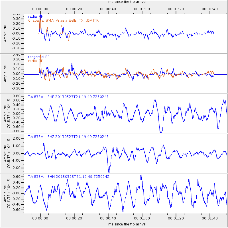
833A Chaparral WMA, Artesia Wells, TX, USA - Earthquake Result Viewer
*The percent match for this event was below the threshold and hence no stack was calculated.
| Earthquake location: |
Tonga Islands |
| Earthquake latitude/longitude: |
-20.6/-175.8 |
| Earthquake time(UTC): |
2013/05/23 (143) 21:07:46 GMT |
| Earthquake Depth: |
150 km |
| Earthquake Magnitude: |
6.3 MW, 5.7 MB, 6.3 MW |
| Earthquake Catalog/Contributor: |
NEIC PDE/NEIC PDE-W |
|
| Network: |
TA USArray Transportable Network (new EarthScope stations) |
| Station: |
833A Chaparral WMA, Artesia Wells, TX, USA |
| Lat/Lon: |
28.32 N/99.39 W |
| Elevation: |
171 m |
|
| Distance: |
88.3 deg |
| Az: |
58.997 deg |
| Baz: |
245.639 deg |
| Ray Param: |
$rayparam |
*The percent match for this event was below the threshold and hence was not used in the summary stack. |
|
| Radial Match: |
59.10973 % |
| Radial Bump: |
312 |
| Transverse Match: |
62.494015 % |
| Transverse Bump: |
371 |
| SOD ConfigId: |
512894 |
| Insert Time: |
2013-09-14 16:33:32.821 +0000 |
| GWidth: |
2.5 |
| Max Bumps: |
400 |
| Tol: |
0.001 |
|
Signal To Noise
| Channel | StoN | STA | LTA |
| TA:833A: :BHZ:20130523T21:19:49.725024Z | 2.6699376 | 5.41299E-7 | 2.0273843E-7 |
| TA:833A: :BHN:20130523T21:19:49.725024Z | 1.5196241 | 3.3494734E-7 | 2.2041462E-7 |
| TA:833A: :BHE:20130523T21:19:49.725024Z | 0.7821509 | 1.6823948E-7 | 2.1509848E-7 |
| Arrivals |
| Ps | |
| PpPs | |
| PsPs/PpSs | |


