You are here: Home > Network List > TA - USArray Transportable Network (new EarthScope stations) Stations List
> Station MDND Maddock, ND, USA > Earthquake Result Viewer
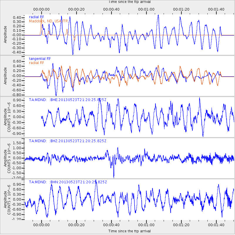
MDND Maddock, ND, USA - Earthquake Result Viewer
*The percent match for this event was below the threshold and hence no stack was calculated.
| Earthquake location: |
Tonga Islands |
| Earthquake latitude/longitude: |
-20.6/-175.8 |
| Earthquake time(UTC): |
2013/05/23 (143) 21:07:46 GMT |
| Earthquake Depth: |
150 km |
| Earthquake Magnitude: |
6.3 MW, 5.7 MB, 6.3 MW |
| Earthquake Catalog/Contributor: |
NEIC PDE/NEIC PDE-W |
|
| Network: |
TA USArray Transportable Network (new EarthScope stations) |
| Station: |
MDND Maddock, ND, USA |
| Lat/Lon: |
47.85 N/99.60 W |
| Elevation: |
479 m |
|
| Distance: |
96.2 deg |
| Az: |
41.132 deg |
| Baz: |
246.21 deg |
| Ray Param: |
$rayparam |
*The percent match for this event was below the threshold and hence was not used in the summary stack. |
|
| Radial Match: |
61.32653 % |
| Radial Bump: |
400 |
| Transverse Match: |
53.146374 % |
| Transverse Bump: |
400 |
| SOD ConfigId: |
512894 |
| Insert Time: |
2013-09-14 16:34:40.311 +0000 |
| GWidth: |
2.5 |
| Max Bumps: |
400 |
| Tol: |
0.001 |
|
Signal To Noise
| Channel | StoN | STA | LTA |
| TA:MDND: :BHZ:20130523T21:20:25.825Z | 1.8230984 | 2.505293E-7 | 1.3741952E-7 |
| TA:MDND: :BHN:20130523T21:20:25.825Z | 1.7731571 | 5.74452E-7 | 3.2397128E-7 |
| TA:MDND: :BHE:20130523T21:20:25.825Z | 2.1209433 | 5.549711E-7 | 2.616624E-7 |
| Arrivals |
| Ps | |
| PpPs | |
| PsPs/PpSs | |


