You are here: Home > Network List > PS - Pacific21 Stations List
> Station TSK Tsukuba, Japan > Earthquake Result Viewer
TSK Tsukuba, Japan - Earthquake Result Viewer

| Earthquake location: |
Tonga Islands |
| Earthquake latitude/longitude: |
-21.3/-174.4 |
| Earthquake time(UTC): |
1997/09/10 (253) 12:57:07 GMT |
| Earthquake Depth: |
10 km |
| Earthquake Magnitude: |
5.7 MB, 6.1 MS, 6.1 UNKNOWN, 5.9 MW |
| Earthquake Catalog/Contributor: |
WHDF/NEIC |
|
| Network: |
PS Pacific21 |
| Station: |
TSK Tsukuba, Japan |
| Lat/Lon: |
36.21 N/140.11 E |
| Elevation: |
350 m |
|
| Distance: |
71.6 deg |
| Az: |
322.561 deg |
| Baz: |
135.514 deg |
| Ray Param: |
0.054214038 |
| Estimated Moho Depth: |
50.25 km |
| Estimated Crust Vp/Vs: |
1.75 |
| Assumed Crust Vp: |
6.24 km/s |
| Estimated Crust Vs: |
3.571 km/s |
| Estimated Crust Poisson's Ratio: |
0.26 |
|
| Radial Match: |
84.47176 % |
| Radial Bump: |
307 |
| Transverse Match: |
79.98213 % |
| Transverse Bump: |
400 |
| SOD ConfigId: |
6273 |
| Insert Time: |
2010-02-27 03:55:04.473 +0000 |
| GWidth: |
2.5 |
| Max Bumps: |
400 |
| Tol: |
0.001 |
|
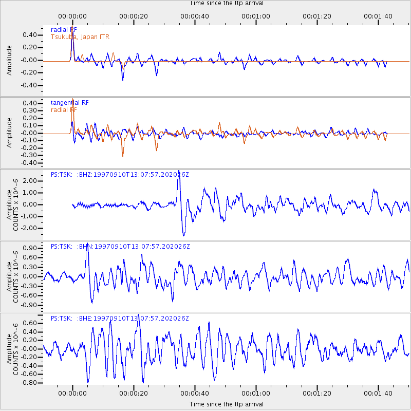
Signal To Noise
| Channel | StoN | STA | LTA |
| PS:TSK: :BHN:19970910T13:07:57.202026Z | 3.6225643 | 3.0471355E-7 | 8.411543E-8 |
| PS:TSK: :BHE:19970910T13:07:57.202026Z | 1.5001457 | 1.7106132E-7 | 1.140298E-7 |
| PS:TSK: :BHZ:19970910T13:07:57.202026Z | 6.1907163 | 8.3134233E-7 | 1.3428856E-7 |
| Arrivals |
| Ps | 6.2 SECOND |
| PpPs | 21 SECOND |
| PsPs/PpSs | 28 SECOND |


