You are here: Home > Network List > PS - Pacific21 Stations List
> Station TSK Tsukuba, Japan > Earthquake Result Viewer
TSK Tsukuba, Japan - Earthquake Result Viewer

| Earthquake location: |
Xizang |
| Earthquake latitude/longitude: |
35.1/87.3 |
| Earthquake time(UTC): |
1997/11/08 (312) 10:02:52 GMT |
| Earthquake Depth: |
33 km |
| Earthquake Magnitude: |
6.2 MB, 7.9 MS, 7.7 UNKNOWN, 7.6 MW |
| Earthquake Catalog/Contributor: |
WHDF/NEIC |
|
| Network: |
PS Pacific21 |
| Station: |
TSK Tsukuba, Japan |
| Lat/Lon: |
36.21 N/140.11 E |
| Elevation: |
350 m |
|
| Distance: |
42.5 deg |
| Az: |
72.531 deg |
| Baz: |
284.651 deg |
| Ray Param: |
0.07309591 |
| Estimated Moho Depth: |
24.5 km |
| Estimated Crust Vp/Vs: |
1.61 |
| Assumed Crust Vp: |
6.24 km/s |
| Estimated Crust Vs: |
3.87 km/s |
| Estimated Crust Poisson's Ratio: |
0.19 |
|
| Radial Match: |
92.37658 % |
| Radial Bump: |
357 |
| Transverse Match: |
81.48055 % |
| Transverse Bump: |
400 |
| SOD ConfigId: |
6273 |
| Insert Time: |
2010-02-27 03:55:09.053 +0000 |
| GWidth: |
2.5 |
| Max Bumps: |
400 |
| Tol: |
0.001 |
|
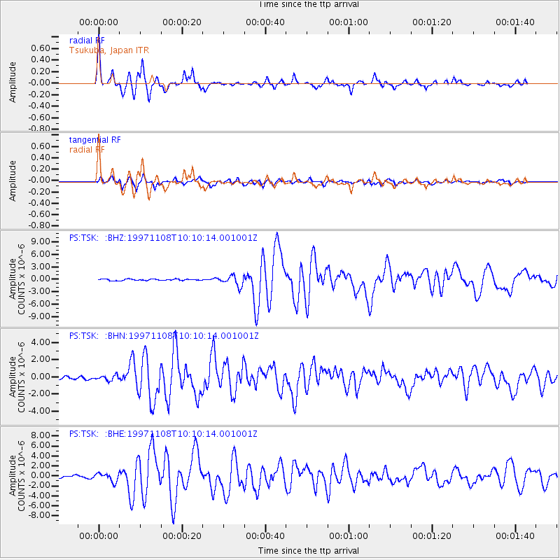
Signal To Noise
| Channel | StoN | STA | LTA |
| PS:TSK: :BHN:19971108T10:10:14.001001Z | 1.4940815 | 2.9388173E-7 | 1.9669726E-7 |
| PS:TSK: :BHE:19971108T10:10:14.001001Z | 4.460513 | 8.732845E-7 | 1.9578117E-7 |
| PS:TSK: :BHZ:19971108T10:10:14.001001Z | 7.763223 | 1.2895562E-6 | 1.6611092E-7 |
| Arrivals |
| Ps | 2.6 SECOND |
| PpPs | 9.6 SECOND |
| PsPs/PpSs | 12 SECOND |


