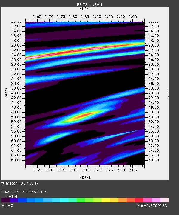
TSK Tsukuba, Japan - Earthquake Result Viewer

Earthquake location: Afghanistan-Tajikistan Bord Reg.
Earthquake latitude/longitude: 36.5/71.1
Earthquake time(UTC): 1998/02/20 (051) 12:18:06 GMT
Earthquake Depth: 236 km
Earthquake Magnitude: 5.8 MB, 5.7 MS, 6.4 UNKNOWN, 6.3 MW
Earthquake Catalog/Contributor: WHDF/NEIC
Network: PS Pacific21
Station: TSK Tsukuba, Japan
Lat/Lon: 36.21 N/140.11 E
Elevation: 350 m
Distance: 54.4 deg
Az: 68.158 deg
Baz: 292.324 deg
Ray Param: 0.0646086
Estimated Moho Depth: 25.25 km
Estimated Crust Vp/Vs: 1.60
Assumed Crust Vp: 6.24 km/s
Estimated Crust Vs: 3.9 km/s
Estimated Crust Poisson's Ratio: 0.18
Radial Match: 83.43547 %
Radial Bump: 400
Transverse Match: 69.93729 %
Transverse Bump: 400
SOD ConfigId: 6273
Insert Time: 2010-02-27 03:55:12.387 +0000
GWidth: 2.5
Max Bumps: 400
Tol: 0.001

Signal To Noise

ChannelStoNSTALTA
PS:TSK: :BHN:19980220T12:26:38.450Z1.66769916.196387E-73.7155303E-7
PS:TSK: :BHE:19980220T12:26:38.450Z2.43681386.7976674E-72.7895717E-7
PS:TSK: :BHZ:19980220T12:26:38.450Z1.90045578.434872E-74.4383418E-7
Arrivals
Ps2.6 SECOND
PpPs10.0 SECOND
PsPs/PpSs13 SECOND