You are here: Home > Network List > PS - Pacific21 Stations List
> Station TSK Tsukuba, Japan > Earthquake Result Viewer
TSK Tsukuba, Japan - Earthquake Result Viewer

| Earthquake location: |
Southeast Indian Ridge |
| Earthquake latitude/longitude: |
-45.2/96.9 |
| Earthquake time(UTC): |
2005/10/29 (302) 04:05:56 GMT |
| Earthquake Depth: |
8.0 km |
| Earthquake Magnitude: |
6.1 MB, 6.2 MS, 6.5 MW, 6.4 MW |
| Earthquake Catalog/Contributor: |
WHDF/NEIC |
|
| Network: |
PS Pacific21 |
| Station: |
TSK Tsukuba, Japan |
| Lat/Lon: |
36.21 N/140.11 E |
| Elevation: |
350 m |
|
| Distance: |
90.0 deg |
| Az: |
33.624 deg |
| Baz: |
208.945 deg |
| Ray Param: |
0.041707277 |
| Estimated Moho Depth: |
58.75 km |
| Estimated Crust Vp/Vs: |
1.91 |
| Assumed Crust Vp: |
6.24 km/s |
| Estimated Crust Vs: |
3.271 km/s |
| Estimated Crust Poisson's Ratio: |
0.31 |
|
| Radial Match: |
95.3065 % |
| Radial Bump: |
253 |
| Transverse Match: |
88.90109 % |
| Transverse Bump: |
400 |
| SOD ConfigId: |
2564 |
| Insert Time: |
2010-02-27 03:55:16.898 +0000 |
| GWidth: |
2.5 |
| Max Bumps: |
400 |
| Tol: |
0.001 |
|
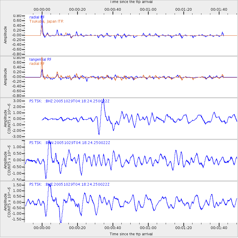
Signal To Noise
| Channel | StoN | STA | LTA |
| PS:TSK: :BHN:20051029T04:18:24.250022Z | 8.554373 | 8.4307595E-7 | 9.855497E-8 |
| PS:TSK: :BHE:20051029T04:18:24.250022Z | 5.5219417 | 8.65268E-7 | 1.5669634E-7 |
| PS:TSK: :BHZ:20051029T04:18:24.250022Z | 10.922664 | 1.6890854E-6 | 1.5464043E-7 |
| Arrivals |
| Ps | 8.7 SECOND |
| PpPs | 27 SECOND |
| PsPs/PpSs | 36 SECOND |


