You are here: Home > Network List > TA - USArray Transportable Network (new EarthScope stations) Stations List
> Station V53A Saluda, NC, USA > Earthquake Result Viewer
V53A Saluda, NC, USA - Earthquake Result Viewer
| Earthquake location: |
Northern California |
| Earthquake latitude/longitude: |
40.2/-121.1 |
| Earthquake time(UTC): |
2013/05/24 (144) 03:47:08 GMT |
| Earthquake Depth: |
9.7 km |
| Earthquake Magnitude: |
5.7 MW, 5.7 MB, 5.7 MW |
| Earthquake Catalog/Contributor: |
NEIC PDE/NEIC PDE-W |
|
| Network: |
TA USArray Transportable Network (new EarthScope stations) |
| Station: |
V53A Saluda, NC, USA |
| Lat/Lon: |
35.67 N/82.81 W |
| Elevation: |
681 m |
|
| Distance: |
30.3 deg |
| Az: |
86.183 deg |
| Baz: |
290.168 deg |
| Ray Param: |
0.079357184 |
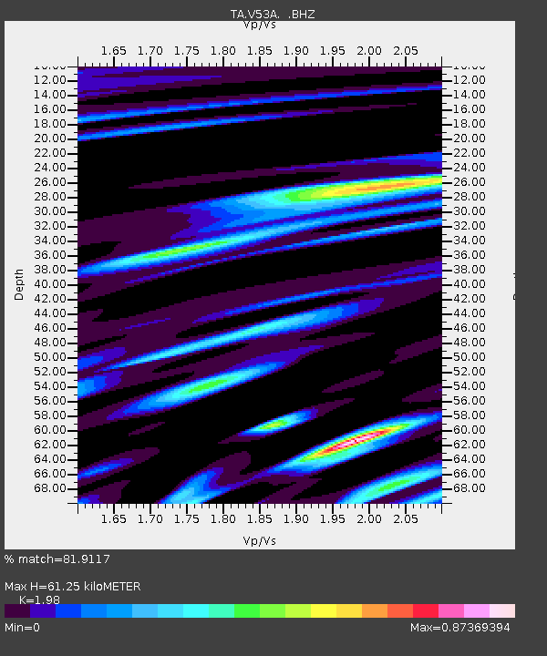
| Estimated Moho Depth: |
61.25 km |
| Estimated Crust Vp/Vs: |
1.98 |
| Assumed Crust Vp: |
6.35 km/s |
| Estimated Crust Vs: |
3.207 km/s |
| Estimated Crust Poisson's Ratio: |
0.33 |
|
| Radial Match: |
81.9117 % |
| Radial Bump: |
400 |
| Transverse Match: |
63.201893 % |
| Transverse Bump: |
400 |
| SOD ConfigId: |
512894 |
| Insert Time: |
2013-09-14 17:02:00.830 +0000 |
| GWidth: |
2.5 |
| Max Bumps: |
400 |
| Tol: |
0.001 |
|

Signal To Noise
| Channel | StoN | STA | LTA |
| TA:V53A: :BHZ:20130524T03:52:49.299995Z | 2.1172 | 2.2838711E-7 | 1.07872246E-7 |
| TA:V53A: :BHN:20130524T03:52:49.299995Z | 1.2418019 | 9.726907E-8 | 7.832897E-8 |
| TA:V53A: :BHE:20130524T03:52:49.299995Z | 1.3137064 | 1.16928504E-7 | 8.900657E-8 |
| Arrivals |
| Ps | 10 SECOND |
| PpPs | 27 SECOND |
| PsPs/PpSs | 37 SECOND |


