You are here: Home > Network List > TA - USArray Transportable Network (new EarthScope stations) Stations List
> Station W56A Indian Trail, NC, USA > Earthquake Result Viewer
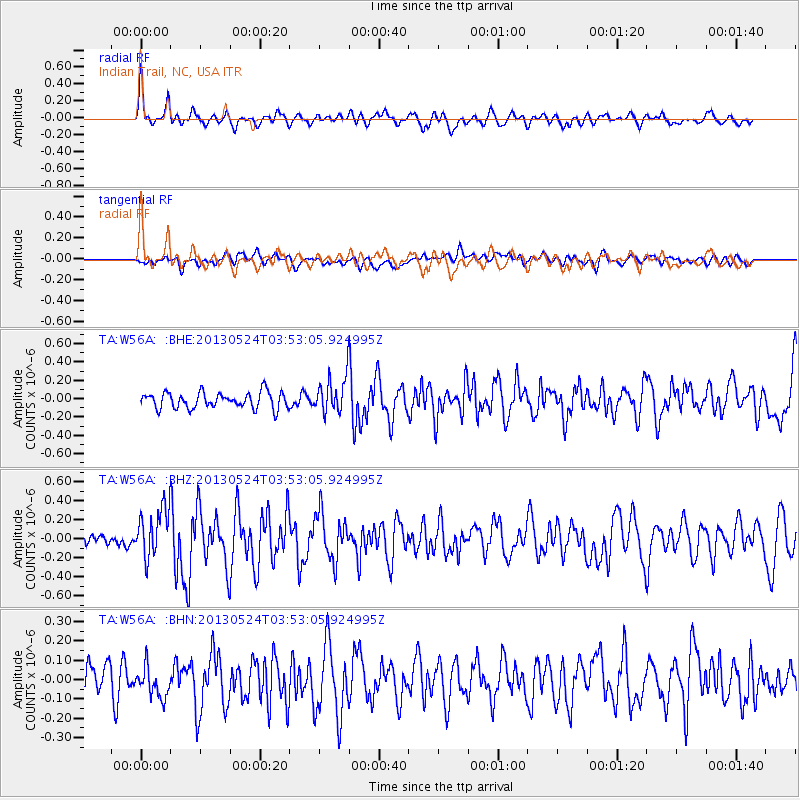
W56A Indian Trail, NC, USA - Earthquake Result Viewer
*The percent match for this event was below the threshold and hence no stack was calculated.
| Earthquake location: |
Northern California |
| Earthquake latitude/longitude: |
40.2/-121.1 |
| Earthquake time(UTC): |
2013/05/24 (144) 03:47:08 GMT |
| Earthquake Depth: |
9.7 km |
| Earthquake Magnitude: |
5.7 MW, 5.7 MB, 5.7 MW |
| Earthquake Catalog/Contributor: |
NEIC PDE/NEIC PDE-W |
|
| Network: |
TA USArray Transportable Network (new EarthScope stations) |
| Station: |
W56A Indian Trail, NC, USA |
| Lat/Lon: |
35.13 N/80.58 W |
| Elevation: |
177 m |
|
| Distance: |
32.2 deg |
| Az: |
85.904 deg |
| Baz: |
291.216 deg |
| Ray Param: |
$rayparam |
*The percent match for this event was below the threshold and hence was not used in the summary stack. |
|
| Radial Match: |
63.515774 % |
| Radial Bump: |
400 |
| Transverse Match: |
45.34435 % |
| Transverse Bump: |
400 |
| SOD ConfigId: |
512894 |
| Insert Time: |
2013-09-14 17:02:28.754 +0000 |
| GWidth: |
2.5 |
| Max Bumps: |
400 |
| Tol: |
0.001 |
|
Signal To Noise
| Channel | StoN | STA | LTA |
| TA:W56A: :BHZ:20130524T03:53:05.924995Z | 2.4620292 | 2.6418468E-7 | 1.07303634E-7 |
| TA:W56A: :BHN:20130524T03:53:05.924995Z | 0.71846455 | 7.321605E-8 | 1.01906274E-7 |
| TA:W56A: :BHE:20130524T03:53:05.924995Z | 2.1912463 | 1.8978568E-7 | 8.661084E-8 |
| Arrivals |
| Ps | |
| PpPs | |
| PsPs/PpSs | |


