You are here: Home > Network List > AK - Alaska Regional Network Stations List
> Station BGLC Bering Glacier BLM Camp, AK, USA > Earthquake Result Viewer
BGLC Bering Glacier BLM Camp, AK, USA - Earthquake Result Viewer
| Earthquake location: |
Sea Of Okhotsk |
| Earthquake latitude/longitude: |
54.9/153.2 |
| Earthquake time(UTC): |
2013/05/24 (144) 05:44:48 GMT |
| Earthquake Depth: |
598 km |
| Earthquake Magnitude: |
8.4 MW, 7.5 MB, 8.3 MW |
| Earthquake Catalog/Contributor: |
NEIC PDE/NEIC PDE-W |
|
| Network: |
AK Alaska Regional Network |
| Station: |
BGLC Bering Glacier BLM Camp, AK, USA |
| Lat/Lon: |
60.12 N/143.28 W |
| Elevation: |
10 m |
|
| Distance: |
33.3 deg |
| Az: |
54.663 deg |
| Baz: |
289.74 deg |
| Ray Param: |
0.07529614 |
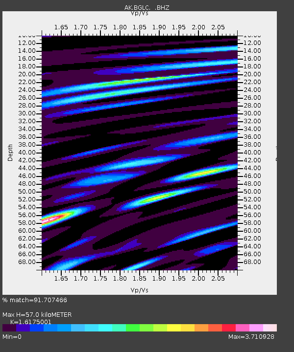
| Estimated Moho Depth: |
57.0 km |
| Estimated Crust Vp/Vs: |
1.62 |
| Assumed Crust Vp: |
6.566 km/s |
| Estimated Crust Vs: |
4.059 km/s |
| Estimated Crust Poisson's Ratio: |
0.19 |
|
| Radial Match: |
91.707466 % |
| Radial Bump: |
400 |
| Transverse Match: |
86.49633 % |
| Transverse Bump: |
400 |
| SOD ConfigId: |
512894 |
| Insert Time: |
2013-09-14 17:06:00.037 +0000 |
| GWidth: |
2.5 |
| Max Bumps: |
400 |
| Tol: |
0.001 |
|

Signal To Noise
| Channel | StoN | STA | LTA |
| AK:BGLC: :BHZ:20130524T05:50:08.427998Z | 21.32373 | 1.0474648E-4 | 4.9122027E-6 |
| AK:BGLC: :BHN:20130524T05:50:08.427998Z | 22.009104 | 4.498179E-5 | 2.043781E-6 |
| AK:BGLC: :BHE:20130524T05:50:08.427998Z | 14.597387 | 5.1184066E-5 | 3.5063856E-6 |
| Arrivals |
| Ps | 5.8 SECOND |
| PpPs | 21 SECOND |
| PsPs/PpSs | 27 SECOND |


