You are here: Home > Network List > PS - Pacific21 Stations List
> Station TSK Tsukuba, Japan > Earthquake Result Viewer
TSK Tsukuba, Japan - Earthquake Result Viewer
| Earthquake location: |
South Of Fiji Islands |
| Earthquake latitude/longitude: |
-22.2/-179.5 |
| Earthquake time(UTC): |
1998/05/16 (136) 02:22:03 GMT |
| Earthquake Depth: |
586 km |
| Earthquake Magnitude: |
6.1 MB, 6.8 UNKNOWN |
| Earthquake Catalog/Contributor: |
WHDF/NEIC |
|
| Network: |
PS Pacific21 |
| Station: |
TSK Tsukuba, Japan |
| Lat/Lon: |
36.21 N/140.11 E |
| Elevation: |
350 m |
|
| Distance: |
69.5 deg |
| Az: |
326.003 deg |
| Baz: |
140.162 deg |
| Ray Param: |
0.053536255 |
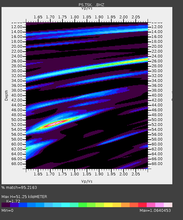
| Estimated Moho Depth: |
51.25 km |
| Estimated Crust Vp/Vs: |
1.72 |
| Assumed Crust Vp: |
6.24 km/s |
| Estimated Crust Vs: |
3.628 km/s |
| Estimated Crust Poisson's Ratio: |
0.24 |
|
| Radial Match: |
95.2163 % |
| Radial Bump: |
400 |
| Transverse Match: |
88.29104 % |
| Transverse Bump: |
400 |
| SOD ConfigId: |
4480 |
| Insert Time: |
2010-02-27 03:55:24.233 +0000 |
| GWidth: |
2.5 |
| Max Bumps: |
400 |
| Tol: |
0.001 |
|

Signal To Noise
| Channel | StoN | STA | LTA |
| PS:TSK: :BHZ:19980516T02:31:43.101001Z | 66.9134 | 8.4229305E-6 | 1.2587809E-7 |
| PS:TSK: :BHN:19980516T02:31:43.101001Z | 31.219631 | 2.677845E-6 | 8.5774396E-8 |
| PS:TSK: :BHE:19980516T02:31:43.101001Z | 11.447111 | 1.0954851E-6 | 9.5699704E-8 |
| Arrivals |
| Ps | 6.1 SECOND |
| PpPs | 22 SECOND |
| PsPs/PpSs | 28 SECOND |


