You are here: Home > Network List > AK - Alaska Regional Network Stations List
> Station KULT Kultieth River Mtn, AK, USA > Earthquake Result Viewer
KULT Kultieth River Mtn, AK, USA - Earthquake Result Viewer
| Earthquake location: |
Sea Of Okhotsk |
| Earthquake latitude/longitude: |
54.9/153.2 |
| Earthquake time(UTC): |
2013/05/24 (144) 05:44:48 GMT |
| Earthquake Depth: |
598 km |
| Earthquake Magnitude: |
8.4 MW, 7.5 MB, 8.3 MW |
| Earthquake Catalog/Contributor: |
NEIC PDE/NEIC PDE-W |
|
| Network: |
AK Alaska Regional Network |
| Station: |
KULT Kultieth River Mtn, AK, USA |
| Lat/Lon: |
60.25 N/142.72 W |
| Elevation: |
1006 m |
|
| Distance: |
33.5 deg |
| Az: |
54.273 deg |
| Baz: |
289.901 deg |
| Ray Param: |
0.07517971 |
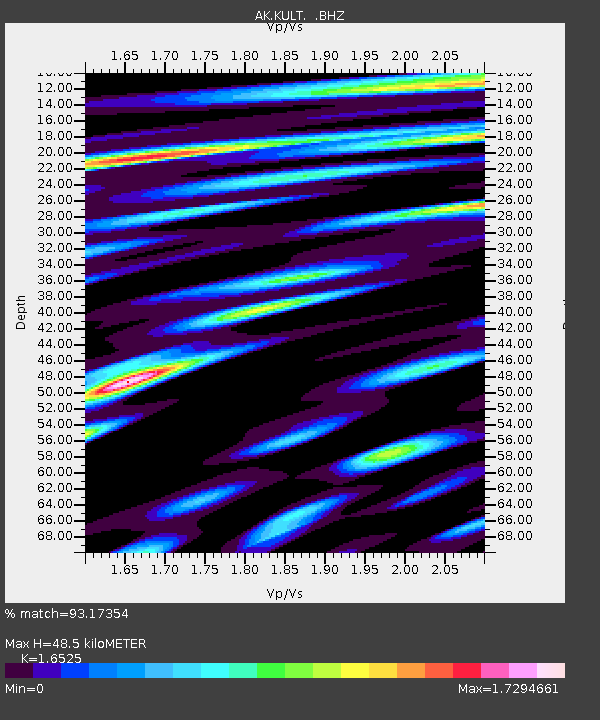
| Estimated Moho Depth: |
48.5 km |
| Estimated Crust Vp/Vs: |
1.65 |
| Assumed Crust Vp: |
6.566 km/s |
| Estimated Crust Vs: |
3.973 km/s |
| Estimated Crust Poisson's Ratio: |
0.21 |
|
| Radial Match: |
93.17354 % |
| Radial Bump: |
400 |
| Transverse Match: |
90.689445 % |
| Transverse Bump: |
400 |
| SOD ConfigId: |
512894 |
| Insert Time: |
2013-09-14 17:06:49.728 +0000 |
| GWidth: |
2.5 |
| Max Bumps: |
400 |
| Tol: |
0.001 |
|

Signal To Noise
| Channel | StoN | STA | LTA |
| AK:KULT: :BHZ:20130524T05:50:10.267994Z | 13.478657 | 8.121284E-5 | 6.025292E-6 |
| AK:KULT: :BHN:20130524T05:50:10.267994Z | 39.552967 | 3.921914E-5 | 9.9156E-7 |
| AK:KULT: :BHE:20130524T05:50:10.267994Z | 11.74154 | 4.9257324E-5 | 4.195133E-6 |
| Arrivals |
| Ps | 5.2 SECOND |
| PpPs | 18 SECOND |
| PsPs/PpSs | 23 SECOND |


