You are here: Home > Network List > CC - Cascade Chain Volcano Monitoring Stations List
> Station PANH Panhandle Gap, Mt. Rainier, WA > Earthquake Result Viewer
PANH Panhandle Gap, Mt. Rainier, WA - Earthquake Result Viewer
| Earthquake location: |
Sea Of Okhotsk |
| Earthquake latitude/longitude: |
54.9/153.2 |
| Earthquake time(UTC): |
2013/05/24 (144) 05:44:48 GMT |
| Earthquake Depth: |
598 km |
| Earthquake Magnitude: |
8.4 MW, 7.5 MB, 8.3 MW |
| Earthquake Catalog/Contributor: |
NEIC PDE/NEIC PDE-W |
|
| Network: |
CC Cascade Chain Volcano Monitoring |
| Station: |
PANH Panhandle Gap, Mt. Rainier, WA |
| Lat/Lon: |
46.86 N/121.64 W |
| Elevation: |
2109 m |
|
| Distance: |
51.1 deg |
| Az: |
61.405 deg |
| Baz: |
312.34 deg |
| Ray Param: |
0.0648384 |
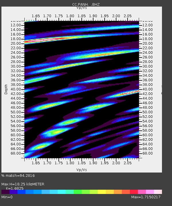
| Estimated Moho Depth: |
18.25 km |
| Estimated Crust Vp/Vs: |
1.68 |
| Assumed Crust Vp: |
6.597 km/s |
| Estimated Crust Vs: |
3.921 km/s |
| Estimated Crust Poisson's Ratio: |
0.23 |
|
| Radial Match: |
94.2816 % |
| Radial Bump: |
400 |
| Transverse Match: |
89.90115 % |
| Transverse Bump: |
400 |
| SOD ConfigId: |
512894 |
| Insert Time: |
2013-09-14 17:11:47.479 +0000 |
| GWidth: |
2.5 |
| Max Bumps: |
400 |
| Tol: |
0.001 |
|

Signal To Noise
| Channel | StoN | STA | LTA |
| CC:PANH: :BHZ:20130524T05:52:27.279988Z | 41.065308 | 4.628784E-5 | 1.1271762E-6 |
| CC:PANH: :BHN:20130524T05:52:27.279988Z | 123.19847 | 4.7394275E-5 | 3.8469858E-7 |
| CC:PANH: :BHE:20130524T05:52:27.279988Z | 107.535995 | 6.251677E-5 | 5.8135663E-7 |
| Arrivals |
| Ps | 2.0 SECOND |
| PpPs | 7.0 SECOND |
| PsPs/PpSs | 9.0 SECOND |


