You are here: Home > Network List > YB13 - Continental Dynamics/Cent. Anatolian Tectonics:Surface to Mantle Dynamics During Stations List
> Station AT68 Hudutkoy,Malatya,Turkey > Earthquake Result Viewer
AT68 Hudutkoy,Malatya,Turkey - Earthquake Result Viewer
| Earthquake location: |
Bonin Islands, Japan Region |
| Earthquake latitude/longitude: |
27.8/142.9 |
| Earthquake time(UTC): |
2014/08/09 (221) 02:28:43 GMT |
| Earthquake Depth: |
9.7 km |
| Earthquake Magnitude: |
5.2 MW, 5.0 mb |
| Earthquake Catalog/Contributor: |
ISC/ISC |
|
| Network: |
YB Continental Dynamics/Cent. Anatolian Tectonics:Surface to Mantle Dynamics During |
| Station: |
AT68 Hudutkoy,Malatya,Turkey |
| Lat/Lon: |
38.02 N/37.83 E |
| Elevation: |
1336 m |
|
| Distance: |
84.1 deg |
| Az: |
309.941 deg |
| Baz: |
59.338 deg |
| Ray Param: |
0.04571564 |
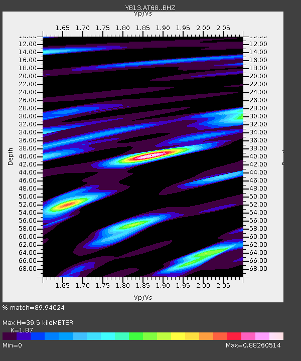
| Estimated Moho Depth: |
39.5 km |
| Estimated Crust Vp/Vs: |
1.87 |
| Assumed Crust Vp: |
6.35 km/s |
| Estimated Crust Vs: |
3.396 km/s |
| Estimated Crust Poisson's Ratio: |
0.30 |
|
| Radial Match: |
89.94024 % |
| Radial Bump: |
400 |
| Transverse Match: |
82.57717 % |
| Transverse Bump: |
400 |
| SOD ConfigId: |
3390531 |
| Insert Time: |
2019-04-13 06:25:30.460 +0000 |
| GWidth: |
2.5 |
| Max Bumps: |
400 |
| Tol: |
0.001 |
|

Signal To Noise
| Channel | StoN | STA | LTA |
| YB:AT68: :BHZ:20140809T02:40:43.359988Z | 3.8284874 | 2.3833661E-7 | 6.225346E-8 |
| YB:AT68: :BHN:20140809T02:40:43.359988Z | 0.7594926 | 3.0179905E-8 | 3.9736936E-8 |
| YB:AT68: :BHE:20140809T02:40:43.359988Z | 2.8253148 | 9.1057096E-8 | 3.2229007E-8 |
| Arrivals |
| Ps | 5.5 SECOND |
| PpPs | 17 SECOND |
| PsPs/PpSs | 23 SECOND |


