You are here: Home > Network List > EI - Irish National Seismic Network (INSN) Stations List
> Station IGLA GLENGOWLA, CO GALWAY, IRELAND > Earthquake Result Viewer
IGLA GLENGOWLA, CO GALWAY, IRELAND - Earthquake Result Viewer
| Earthquake location: |
Sea Of Okhotsk |
| Earthquake latitude/longitude: |
54.9/153.2 |
| Earthquake time(UTC): |
2013/05/24 (144) 05:44:48 GMT |
| Earthquake Depth: |
598 km |
| Earthquake Magnitude: |
8.4 MW, 7.5 MB, 8.3 MW |
| Earthquake Catalog/Contributor: |
NEIC PDE/NEIC PDE-W |
|
| Network: |
EI Irish National Seismic Network (INSN) |
| Station: |
IGLA GLENGOWLA, CO GALWAY, IRELAND |
| Lat/Lon: |
53.42 N/9.38 W |
| Elevation: |
31 m |
|
| Distance: |
71.1 deg |
| Az: |
349.092 deg |
| Baz: |
10.524 deg |
| Ray Param: |
0.052494902 |
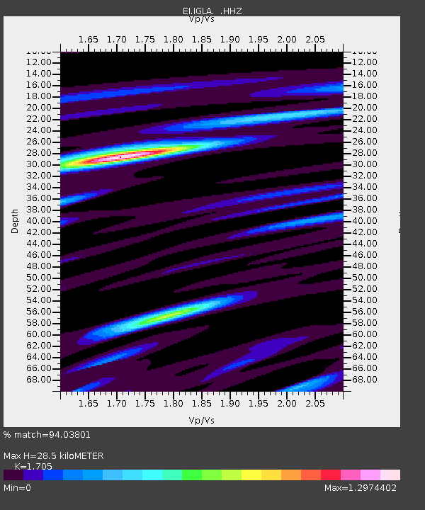
| Estimated Moho Depth: |
28.5 km |
| Estimated Crust Vp/Vs: |
1.71 |
| Assumed Crust Vp: |
6.276 km/s |
| Estimated Crust Vs: |
3.681 km/s |
| Estimated Crust Poisson's Ratio: |
0.24 |
|
| Radial Match: |
94.03801 % |
| Radial Bump: |
400 |
| Transverse Match: |
83.79731 % |
| Transverse Bump: |
400 |
| SOD ConfigId: |
512894 |
| Insert Time: |
2013-09-14 17:16:53.982 +0000 |
| GWidth: |
2.5 |
| Max Bumps: |
400 |
| Tol: |
0.001 |
|

Signal To Noise
| Channel | StoN | STA | LTA |
| EI:IGLA: :HHZ:20130524T05:54:37.099995Z | 8.706586 | 2.1808173E-5 | 2.5047905E-6 |
| EI:IGLA: :HHN:20130524T05:54:37.099995Z | 7.150488 | 8.62579E-6 | 1.2063218E-6 |
| EI:IGLA: :HHE:20130524T05:54:37.099995Z | 4.0038247 | 1.9639908E-6 | 4.905287E-7 |
| Arrivals |
| Ps | 3.3 SECOND |
| PpPs | 12 SECOND |
| PsPs/PpSs | 15 SECOND |


