You are here: Home > Network List > G - GEOSCOPE Stations List
> Station NOUC Port Laguerre, New Caledonia > Earthquake Result Viewer
NOUC Port Laguerre, New Caledonia - Earthquake Result Viewer
| Earthquake location: |
Sea Of Okhotsk |
| Earthquake latitude/longitude: |
54.9/153.2 |
| Earthquake time(UTC): |
2013/05/24 (144) 05:44:48 GMT |
| Earthquake Depth: |
598 km |
| Earthquake Magnitude: |
8.4 MW, 7.5 MB, 8.3 MW |
| Earthquake Catalog/Contributor: |
NEIC PDE/NEIC PDE-W |
|
| Network: |
G GEOSCOPE |
| Station: |
NOUC Port Laguerre, New Caledonia |
| Lat/Lon: |
22.10 S/166.30 E |
| Elevation: |
112 m |
|
| Distance: |
77.5 deg |
| Az: |
167.584 deg |
| Baz: |
352.303 deg |
| Ray Param: |
0.04838227 |
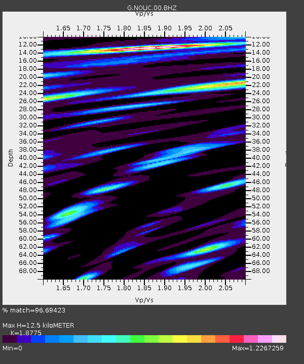
| Estimated Moho Depth: |
12.5 km |
| Estimated Crust Vp/Vs: |
1.88 |
| Assumed Crust Vp: |
5.14 km/s |
| Estimated Crust Vs: |
2.738 km/s |
| Estimated Crust Poisson's Ratio: |
0.30 |
|
| Radial Match: |
96.69423 % |
| Radial Bump: |
400 |
| Transverse Match: |
96.21478 % |
| Transverse Bump: |
400 |
| SOD ConfigId: |
512894 |
| Insert Time: |
2013-09-14 17:17:19.947 +0000 |
| GWidth: |
2.5 |
| Max Bumps: |
400 |
| Tol: |
0.001 |
|

Signal To Noise
| Channel | StoN | STA | LTA |
| G:NOUC:00:BHZ:20130524T05:55:12.899983Z | 7.317431 | 6.214716E-6 | 8.49303E-7 |
| G:NOUC:00:BHN:20130524T05:55:12.899983Z | 4.465324 | 1.8710116E-6 | 4.1900915E-7 |
| G:NOUC:00:BHE:20130524T05:55:12.899983Z | 5.9940634 | 1.3034664E-6 | 2.1745957E-7 |
| Arrivals |
| Ps | 2.2 SECOND |
| PpPs | 6.9 SECOND |
| PsPs/PpSs | 9.1 SECOND |


