You are here: Home > Network List > G - GEOSCOPE Stations List
> Station PPTF Pamatai - Papeete - Tahiti island - French Polynesia, France > Earthquake Result Viewer
PPTF Pamatai - Papeete - Tahiti island - French Polynesia, France - Earthquake Result Viewer
| Earthquake location: |
Sea Of Okhotsk |
| Earthquake latitude/longitude: |
54.9/153.2 |
| Earthquake time(UTC): |
2013/05/24 (144) 05:44:48 GMT |
| Earthquake Depth: |
598 km |
| Earthquake Magnitude: |
8.4 MW, 7.5 MB, 8.3 MW |
| Earthquake Catalog/Contributor: |
NEIC PDE/NEIC PDE-W |
|
| Network: |
G GEOSCOPE |
| Station: |
PPTF Pamatai - Papeete - Tahiti island - French Polynesia, France |
| Lat/Lon: |
17.59 S/149.57 W |
| Elevation: |
705 m |
|
| Distance: |
86.9 deg |
| Az: |
126.581 deg |
| Baz: |
330.898 deg |
| Ray Param: |
0.04195758 |
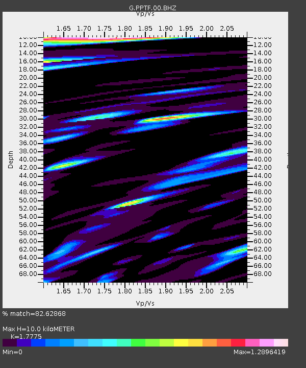
| Estimated Moho Depth: |
10.0 km |
| Estimated Crust Vp/Vs: |
1.78 |
| Assumed Crust Vp: |
4.24 km/s |
| Estimated Crust Vs: |
2.385 km/s |
| Estimated Crust Poisson's Ratio: |
0.27 |
|
| Radial Match: |
82.62868 % |
| Radial Bump: |
400 |
| Transverse Match: |
84.0511 % |
| Transverse Bump: |
400 |
| SOD ConfigId: |
512894 |
| Insert Time: |
2013-09-14 17:17:24.164 +0000 |
| GWidth: |
2.5 |
| Max Bumps: |
400 |
| Tol: |
0.001 |
|
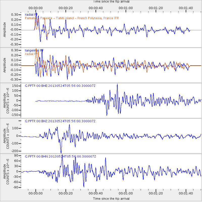
Signal To Noise
| Channel | StoN | STA | LTA |
| G:PPTF:00:BHZ:20130524T05:56:00.300007Z | 5.2873654 | 1.0653542E-5 | 2.0149055E-6 |
| G:PPTF:00:BHN:20130524T05:56:00.300007Z | 1.7310475 | 3.5239323E-6 | 2.0357227E-6 |
| G:PPTF:00:BHE:20130524T05:56:00.300007Z | 3.240281 | 4.3937484E-6 | 1.3559776E-6 |
| Arrivals |
| Ps | 1.9 SECOND |
| PpPs | 6.5 SECOND |
| PsPs/PpSs | 8.3 SECOND |


