You are here: Home > Network List > G - GEOSCOPE Stations List
> Station TAOE Taiohae, Marquises islands > Earthquake Result Viewer
TAOE Taiohae, Marquises islands - Earthquake Result Viewer
| Earthquake location: |
Sea Of Okhotsk |
| Earthquake latitude/longitude: |
54.9/153.2 |
| Earthquake time(UTC): |
2013/05/24 (144) 05:44:48 GMT |
| Earthquake Depth: |
598 km |
| Earthquake Magnitude: |
8.4 MW, 7.5 MB, 8.3 MW |
| Earthquake Catalog/Contributor: |
NEIC PDE/NEIC PDE-W |
|
| Network: |
G GEOSCOPE |
| Station: |
TAOE Taiohae, Marquises islands |
| Lat/Lon: |
8.85 S/140.15 W |
| Elevation: |
800 m |
|
| Distance: |
84.2 deg |
| Az: |
114.232 deg |
| Baz: |
327.786 deg |
| Ray Param: |
0.043905478 |
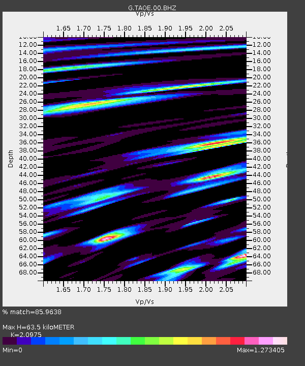
| Estimated Moho Depth: |
63.5 km |
| Estimated Crust Vp/Vs: |
2.10 |
| Assumed Crust Vp: |
4.24 km/s |
| Estimated Crust Vs: |
2.021 km/s |
| Estimated Crust Poisson's Ratio: |
0.35 |
|
| Radial Match: |
85.9638 % |
| Radial Bump: |
400 |
| Transverse Match: |
78.283455 % |
| Transverse Bump: |
400 |
| SOD ConfigId: |
512894 |
| Insert Time: |
2013-09-14 17:17:29.527 +0000 |
| GWidth: |
2.5 |
| Max Bumps: |
400 |
| Tol: |
0.001 |
|
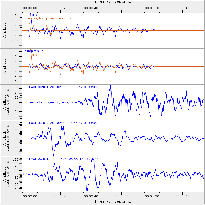
Signal To Noise
| Channel | StoN | STA | LTA |
| G:TAOE:00:BHZ:20130524T05:55:47.039998Z | 5.2357464 | 1.2334986E-5 | 2.3559176E-6 |
| G:TAOE:00:BHN:20130524T05:55:47.039998Z | 2.0411239 | 3.7721645E-6 | 1.8480821E-6 |
| G:TAOE:00:BHE:20130524T05:55:47.039998Z | 2.097282 | 2.9291607E-6 | 1.3966461E-6 |
| Arrivals |
| Ps | 17 SECOND |
| PpPs | 46 SECOND |
| PsPs/PpSs | 63 SECOND |


