You are here: Home > Network List > GO - National Seismic Network of Georgia Stations List
> Station TBLG Delisi, Georgia > Earthquake Result Viewer
TBLG Delisi, Georgia - Earthquake Result Viewer

| Earthquake location: |
Sea Of Okhotsk |
| Earthquake latitude/longitude: |
54.9/153.2 |
| Earthquake time(UTC): |
2013/05/24 (144) 05:44:48 GMT |
| Earthquake Depth: |
598 km |
| Earthquake Magnitude: |
8.4 MW, 7.5 MB, 8.3 MW |
| Earthquake Catalog/Contributor: |
NEIC PDE/NEIC PDE-W |
|
| Network: |
GO National Seismic Network of Georgia |
| Station: |
TBLG Delisi, Georgia |
| Lat/Lon: |
41.73 N/44.74 E |
| Elevation: |
510 m |
|
| Distance: |
66.2 deg |
| Az: |
309.094 deg |
| Baz: |
36.8 deg |
| Ray Param: |
0.055599272 |
| Estimated Moho Depth: |
21.25 km |
| Estimated Crust Vp/Vs: |
1.81 |
| Assumed Crust Vp: |
6.291 km/s |
| Estimated Crust Vs: |
3.476 km/s |
| Estimated Crust Poisson's Ratio: |
0.28 |
|
| Radial Match: |
91.525856 % |
| Radial Bump: |
400 |
| Transverse Match: |
84.717964 % |
| Transverse Bump: |
400 |
| SOD ConfigId: |
512894 |
| Insert Time: |
2013-09-14 17:18:48.270 +0000 |
| GWidth: |
2.5 |
| Max Bumps: |
400 |
| Tol: |
0.001 |
|
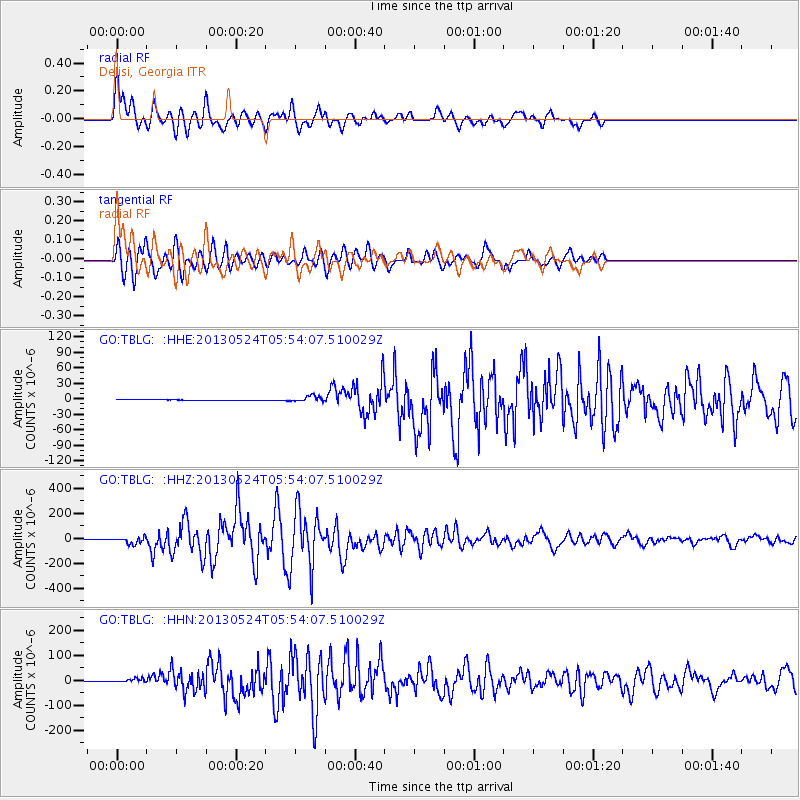
Signal To Noise
| Channel | StoN | STA | LTA |
| GO:TBLG: :HHZ:20130524T05:54:07.510029Z | 15.536038 | 2.7288714E-5 | 1.7564784E-6 |
| GO:TBLG: :HHN:20130524T05:54:07.510029Z | 8.960701 | 6.9005664E-6 | 7.700922E-7 |
| GO:TBLG: :HHE:20130524T05:54:07.510029Z | 9.771592 | 5.937414E-6 | 6.076199E-7 |
| Arrivals |
| Ps | 2.8 SECOND |
| PpPs | 9.2 SECOND |
| PsPs/PpSs | 12 SECOND |


