You are here: Home > Network List > II - Global Seismograph Network (GSN - IRIS/IDA) Stations List
> Station TAU Hobart, Tasmania, Australia > Earthquake Result Viewer
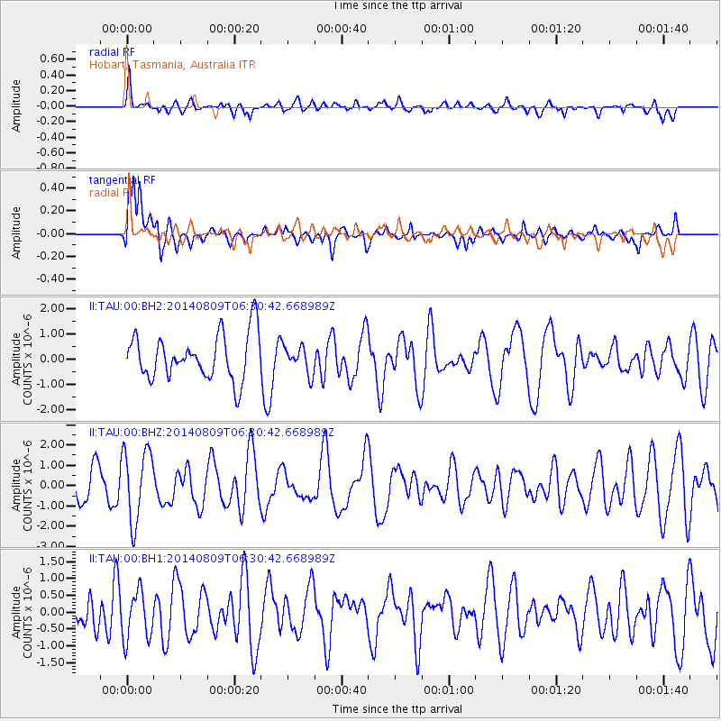
TAU Hobart, Tasmania, Australia - Earthquake Result Viewer
*The percent match for this event was below the threshold and hence no stack was calculated.
| Earthquake location: |
Banda Sea |
| Earthquake latitude/longitude: |
-5.2/131.7 |
| Earthquake time(UTC): |
2014/08/09 (221) 06:23:43 GMT |
| Earthquake Depth: |
54 km |
| Earthquake Magnitude: |
4.6 mb |
| Earthquake Catalog/Contributor: |
ISC/ISC |
|
| Network: |
II Global Seismograph Network (GSN - IRIS/IDA) |
| Station: |
TAU Hobart, Tasmania, Australia |
| Lat/Lon: |
42.91 S/147.32 E |
| Elevation: |
132 m |
|
| Distance: |
40.1 deg |
| Az: |
162.105 deg |
| Baz: |
335.383 deg |
| Ray Param: |
$rayparam |
*The percent match for this event was below the threshold and hence was not used in the summary stack. |
|
| Radial Match: |
67.32206 % |
| Radial Bump: |
400 |
| Transverse Match: |
64.112175 % |
| Transverse Bump: |
400 |
| SOD ConfigId: |
3390531 |
| Insert Time: |
2019-04-13 06:27:20.633 +0000 |
| GWidth: |
2.5 |
| Max Bumps: |
400 |
| Tol: |
0.001 |
|
Signal To Noise
| Channel | StoN | STA | LTA |
| II:TAU:00:BHZ:20140809T06:30:42.668989Z | 1.6898319 | 1.779306E-6 | 1.0529485E-6 |
| II:TAU:00:BH1:20140809T06:30:42.668989Z | 0.936274 | 7.29177E-7 | 7.7880725E-7 |
| II:TAU:00:BH2:20140809T06:30:42.668989Z | 0.59956163 | 5.356229E-7 | 8.9335754E-7 |
| Arrivals |
| Ps | |
| PpPs | |
| PsPs/PpSs | |


