You are here: Home > Network List > II - Global Seismograph Network (GSN - IRIS/IDA) Stations List
> Station CMLA Cha de Macela, Sao Miguel Island, Azores > Earthquake Result Viewer
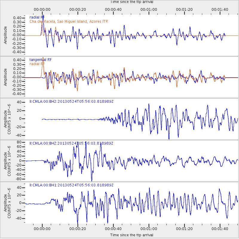
CMLA Cha de Macela, Sao Miguel Island, Azores - Earthquake Result Viewer

| Earthquake location: |
Sea Of Okhotsk |
| Earthquake latitude/longitude: |
54.9/153.2 |
| Earthquake time(UTC): |
2013/05/24 (144) 05:44:48 GMT |
| Earthquake Depth: |
598 km |
| Earthquake Magnitude: |
8.4 MW, 7.5 MB, 8.3 MW |
| Earthquake Catalog/Contributor: |
NEIC PDE/NEIC PDE-W |
|
| Network: |
II Global Seismograph Network (GSN - IRIS/IDA) |
| Station: |
CMLA Cha de Macela, Sao Miguel Island, Azores |
| Lat/Lon: |
37.76 N/25.52 W |
| Elevation: |
429 m |
|
| Distance: |
87.7 deg |
| Az: |
359.005 deg |
| Baz: |
0.725 deg |
| Ray Param: |
0.041702483 |
| Estimated Moho Depth: |
57.75 km |
| Estimated Crust Vp/Vs: |
1.62 |
| Assumed Crust Vp: |
4.802 km/s |
| Estimated Crust Vs: |
2.964 km/s |
| Estimated Crust Poisson's Ratio: |
0.19 |
|
| Radial Match: |
88.07435 % |
| Radial Bump: |
400 |
| Transverse Match: |
82.58518 % |
| Transverse Bump: |
400 |
| SOD ConfigId: |
512894 |
| Insert Time: |
2013-09-14 17:20:44.834 +0000 |
| GWidth: |
2.5 |
| Max Bumps: |
400 |
| Tol: |
0.001 |
|
Signal To Noise
| Channel | StoN | STA | LTA |
| II:CMLA:00:BHZ:20130524T05:56:03.818989Z | 9.51375 | 8.613083E-6 | 9.0533E-7 |
| II:CMLA:00:BH1:20130524T05:56:03.818989Z | 2.9184098 | 1.8183325E-6 | 6.2305594E-7 |
| II:CMLA:00:BH2:20130524T05:56:03.818989Z | 2.672584 | 1.0751623E-6 | 4.022932E-7 |
| Arrivals |
| Ps | 7.6 SECOND |
| PpPs | 31 SECOND |
| PsPs/PpSs | 39 SECOND |


